
Flood Zones and Flood Insurance When Buying a Home in Yuba City (2026)
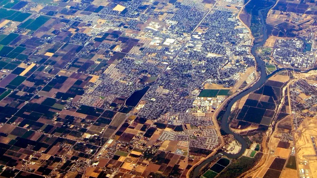
Shopping for a home in Yuba City? Sooner or later you will ask two questions: is this house in a flood zone, and do I need flood insurance?
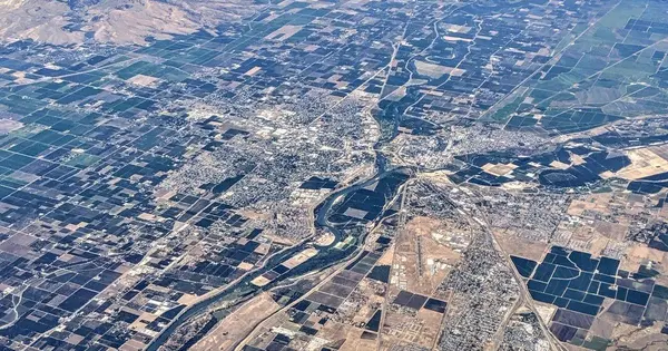
Yuba City sits between the Feather River and the Sutter Bypass, behind one of the most heavily rebuilt levee systems in the Sacramento Valley. This guide explains FEMA flood zones, when lenders require flood insurance, what it costs locally, how to check any address, and what sellers must disclose. Every number links to its source.
Key Takeaways: Yuba City Flood Zones and Flood Insurance, 2026
- Most local flood policies are outside the high-risk zone: 81% of the 2,867 NFIP policies that started in Yuba City ZIP codes 95991 and 95993 in the year ending June 30, 2026 were rated Zone X or C, and 19% were rated Zone A (OpenFEMA).
- Required vs. recommended: flood insurance is required for a federally backed mortgage in a Special Flood Hazard Area (any Zone A, including A99). In Zone X behind a levee it is not federally required, but a lender can still require it and FEMA strongly recommends it.
- Typical cost: the median NFIP single-family policy in those two ZIP codes cost $670 a year (premium plus fees), up from $480 in 2018–19.
- The levee story: the Feather River West Levee Project was completed in 2020 and provides 200-year protection to the urban area from Yuba City north to Biggs, per the Sutter Butte Flood Control Agency’s financing authority.
- Check before you offer: use the FEMA Flood Map Service Center, DWR Best Available Maps, and the Natural Hazard Disclosure, then get a flood quote during your contingency period.
Is Yuba City in a Flood Zone?
Parts of it are, and the answer is address by address. Yuba City participates in the National Flood Insurance Program (NFIP), so every home in the city can buy federal flood insurance, in or out of a high-risk zone (FEMA Community Status Book).
The city’s own Public Works FAQ says a property’s flood zone is set by the Flood Insurance Rate Map (FIRM), and Public Works answers flood-zone questions at (530) 822-4626.
What Do the FEMA Flood Zones Mean?
| Zone | What FEMA says it means | Flood insurance with a federally backed mortgage |
|---|---|---|
| A, AE, AH, AO | High risk: about a 1% annual chance of flooding, or a 26% chance over a 30-year mortgage | Required |
| A99 | High risk, but to be protected by a federal flood control system under construction | Required (it is still a Special Flood Hazard Area) |
| X (shaded) / B | Moderate risk, often areas protected by levees from the 100-year flood | Not federally required; a lender can still require it |
| X (unshaded) / C | Lower risk, but not without risk | Not federally required; recommended |
| D | Possible but undetermined flood hazard | Not federally required; recommended |
Source: FloodSmart: What Is My Flood Zone?, FEMA: Know Your Flood Risk, and FEMA: Living with Levees for real estate and lending professionals.
How Are Local Flood Policies Rated Today?
I pulled every NFIP policy in FEMA’s public OpenFEMA policy data that started between July 1, 2025 and June 30, 2026 with a Yuba City ZIP code (95991 or 95993). Those ZIP codes include some unincorporated Sutter County homes around the city.
| Rated flood zone | Policies | Share |
|---|---|---|
| Zone X | 1,855 | 64.7% |
| Zone C | 464 | 16.2% |
| Zone A (plus 1 AE and 1 AO) | 547 | 19.1% |
| Zone D | 1 | 0.0% |
| Total | 2,867 | 100% |
Source: OpenFEMA FIMA NFIP Redacted Policies v3, queried October 22, 2026 (data as of September 8, 2026). Rated zone is the zone used to rate the policy.
Do I Need Flood Insurance to Buy a Home in Yuba City?
It depends on the zone and your loan.
- Zone A or A99 with a federally backed mortgage: yes. As the City of Yuba City’s flood page puts it, if you live in a Special Flood Hazard Area or high-risk area and have a federally backed mortgage, your lender requires flood insurance. Zone A99 is still a Special Flood Hazard Area (FEMA).
- Zone X behind a levee: not federally required, but FEMA says “a lender can still require it” and urges buyers to strongly consider it, because the flood hazard behind a levee is reduced, not removed (FEMA).
- Paying cash: no lender requirement at all. The decision, and the risk, is yours.
FEMA also points out that more than 20 percent of all flood claims come from moderate- or low-hazard areas (Zone X, shaded or unshaded) (FEMA). Most homeowners insurance does not cover flood damage.
Is There a Waiting Period?
Usually 30 days, but not when you buy it for your purchase loan. Per FloodSmart, there is no wait if you buy flood insurance while making, increasing, extending or renewing a mortgage. Apply on or before your closing date.
What Is the Feather River West Levee Project, and Does It Change My Flood Zone?
The Sutter Butte Flood Control Agency (SBFCA) was formed in 2007 after state studies found deficiencies in the levees around the Yuba City Basin. The agency notes the west Feather River levee had major failures in Yuba City in 1955, and Yuba County saw levee failures in 1986 and 1997.
According to the Feather River West Levee Financing Authority engineer’s report:
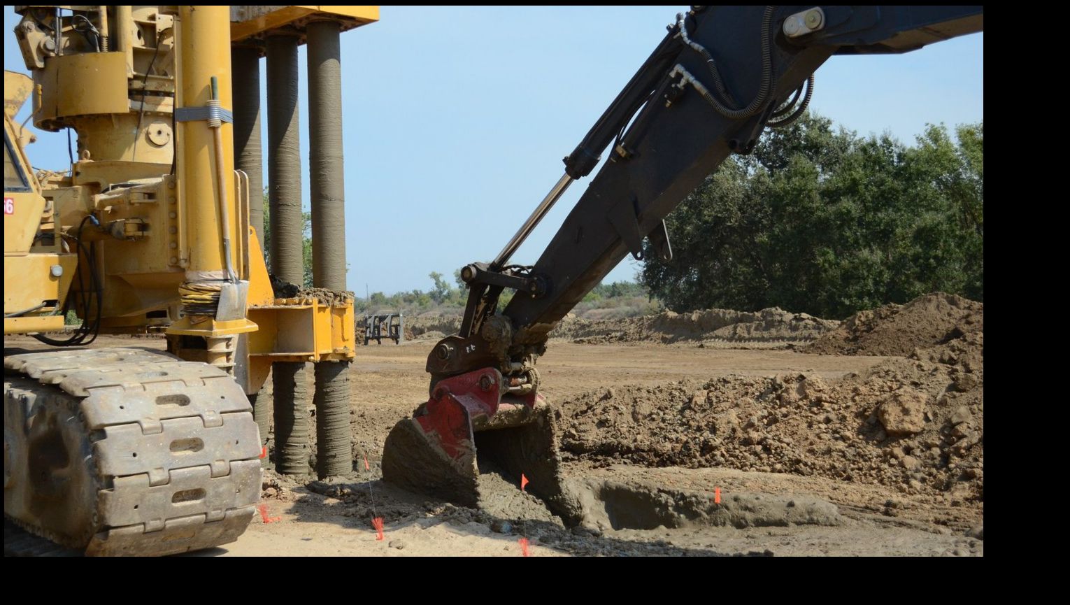
- SBFCA and the state rehabilitated about 37 miles of the west Feather River levee, from Thermalito Afterbay south to Star Bend and at Laurel Avenue.
- The U.S. Army Corps of Engineers repaired another 5.5 miles from Star Bend to the Highway 99 crossing, for 42.5 miles of repaired levee.
- The project was completed in 2020, giving the urban area from Yuba City to north of Biggs protection against 200-year Feather River flows. Areas south of Yuba City got improved, but lower, protection.
- The last 1.5 miles, from Highway 99 to the Sutter Bypass, is slated for repair by SBFCA.
An Independent Panel of Experts letter (September 8, 2021) concurred that the work supports a 200-year Urban Level of Flood Protection for the Feather River West Levee floodplain.
Does a Stronger Levee Mean I Don’t Need Flood Insurance?
No. Levees lower risk; they do not erase it. SBFCA’s own 200-year floodplain mapping report says its post-project maps have not been reviewed or formally adopted by FEMA. Lenders go by the FEMA map in effect, so check the FIRM for the exact address.
Sutter County’s FIRM page adds that FEMA issued an updated Flood Insurance Study for unincorporated Sutter County in July 2015 and mapped most of the Natomas Basin (in the south county) as Zone A99. The county says those A99 areas will change to Zone X after the Natomas levees are finished and recertified.
How Much Does Flood Insurance Cost in Yuba City?
Based on FEMA’s public policy data, the median single-family NFIP policy that started in ZIP codes 95991 and 95993 in the year ending June 30, 2026 cost $670 a year. That figure is FEMA’s total policy cost (premium plus fees and surcharges) across 2,527 single-family policies (OpenFEMA).
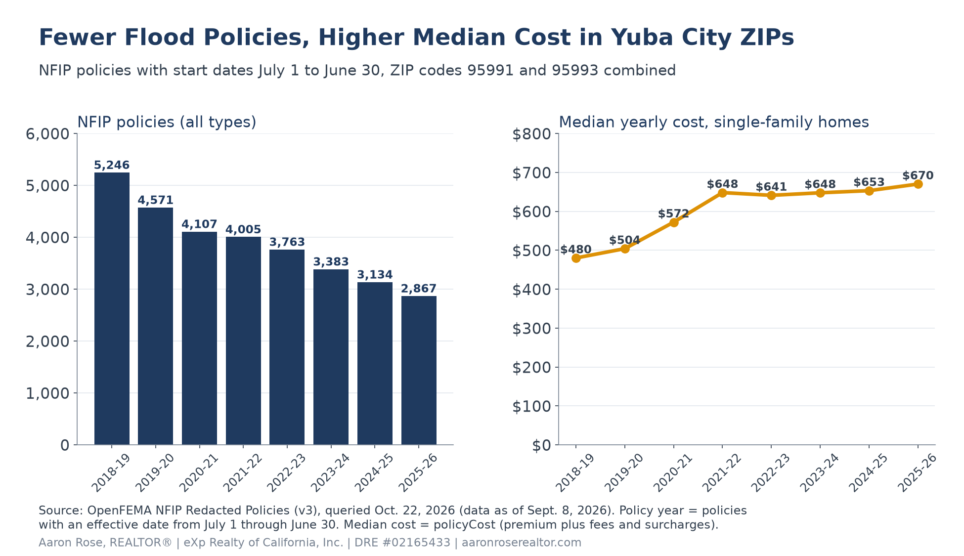
| Policy year (July–June) | NFIP policies | Single-family policies | Median single-family cost |
|---|---|---|---|
| 2018–19 | 5,246 | 4,751 | $480 |
| 2019–20 | 4,571 | 4,141 | $504 |
| 2020–21 | 4,107 | 3,726 | $572 |
| 2021–22 | 4,005 | 3,617 | $648 |
| 2022–23 | 3,763 | 3,344 | $641 |
| 2023–24 | 3,383 | 2,992 | $648 |
| 2024–25 | 3,134 | 2,766 | $653 |
| 2025–26 | 2,867 | 2,527 | $670 |
Source: OpenFEMA FIMA NFIP Redacted Policies v3 (data as of September 8, 2026). A policy year counts policies with an effective date from July 1 through June 30. Your own quote will depend on the specific home.
Why Are Yuba City Flood Policies Discounted?
Yuba City is a Class 6 community in FEMA’s Community Rating System, which earns a 20% discount inside the Special Flood Hazard Area and 10% outside it. Unincorporated Sutter County is also Class 6 with the same discounts, while Live Oak is Class 10 with no discount (FEMA Community Status Book).
What Do NFIP Policies Cover?
- Up to $250,000 for the building and $100,000 for contents on a home (FloodSmart). The median building coverage on 2025–26 single-family policies in these ZIP codes was the full $250,000.
- An NFIP policy can be assigned to the buyer when title transfers, except contents-only policies and policies on buildings under construction (FEMA). Ask the seller if they have one.
Should I Look at Private Flood Insurance?
It is worth a quote. Since July 1, 2019, federally regulated lenders must accept private flood policies that meet the federal definition of “private flood insurance,” and may accept some others (OCC bulletin 2019-8). Compare coverage limits, deductibles, waiting periods, and cancellation terms, not just price.
How Often Do Homes Flood in Sutter County?
FEMA’s public NFIP claims data lists 199 flood insurance claims in Sutter County since 1980, with about $3.04 million paid for building and contents. Most came in a few big storm years, led by 1997 and 1998 (37 claims each) and 2017 (33 claims).
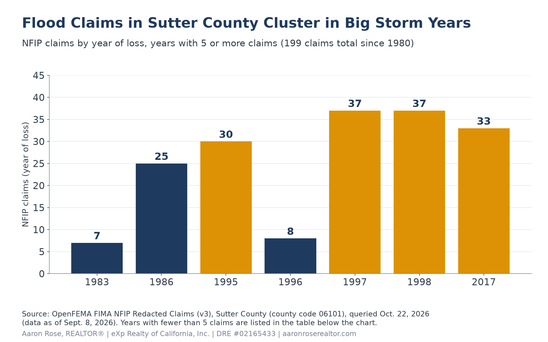
| Year of loss | Claims | Paid (building + contents, not inflation-adjusted) |
|---|---|---|
| 1983 | 7 | $54,989 |
| 1986 | 25 | $302,709 |
| 1995 | 30 | $97,663 |
| 1996 | 8 | $79,188 |
| 1997 | 37 | $1,772,983 |
| 1998 | 37 | $173,512 |
| 2017 | 33 | $360,550 |
| 2024 | 3 | $85,233 |
| All other years | 19 | $117,838 |
| Total | 199 | $3,044,665 |
Source: OpenFEMA FIMA NFIP Redacted Claims v3. “All other years” combines 1980, 1999, 2000, 2001, 2005, 2007, 2008, 2011, 2012, 2016, 2018, 2019, and 2025 (1 to 3 claims each). Only insured losses appear here.
Coverage is thin. FEMA estimates 3,166 residential NFIP contracts in Sutter County, covering about 11.5% of its 27,624 residential structures, as of August 3, 2026 (OpenFEMA NFIP residential penetration rates).
How Do I Check a Yuba City Home’s Flood Risk Before I Make an Offer?
- FEMA Flood Map Service Center: enter the address at msc.fema.gov to see the effective FIRM panel and zone. This is the map lenders use.
- DWR Best Available Maps: the California Department of Water Resources Best Available Maps show state floodplain information beyond the FEMA map, and Sutter County links them from its FIRM page.
- MyHazards: Cal OES’s MyHazards tool shows flood, fire, and earthquake hazards for an address in one place.
- City or county staff: Yuba City Public Works answers flood-zone questions at (530) 822-4626 (city FAQ). The city also keeps elevation certificates for buildings in the Special Flood Hazard Area (Yuba City flood page).
- Ask the seller: request any elevation certificate, past flood claims, and the current flood policy declarations page.
- Get a quote early: call an insurance agent during your inspection contingency, not the week before closing.
What Flood Disclosures Do Yuba City Sellers Have to Give?
California’s Natural Hazard Disclosure (NHD) Statement, set out in Civil Code 1103.2, asks whether the property is in:
- A Special Flood Hazard Area (any Zone A or V) designated by FEMA
- An area of potential flooding shown on a dam failure inundation map
- Plus fire hazard, wildland, earthquake fault, and seismic hazard zones
If FEMA has issued a Letter of Map Revision confirming a property is no longer in a Special Flood Hazard Area, the seller may mark “No” even before the map is updated, and attaches a copy of the letter. Most sellers use a third-party NHD report, which buyers should read closely.
Want a feel for neighborhoods, parks, and commutes before you start checking maps? See my Yuba City neighborhood guide.
What This Means If You Want to Buy
Flood zones should not scare you off Yuba City. They should be part of your homework, like the inspection and the appraisal.
- Check the zone first. Look up the FEMA map for every home you are serious about, and read the NHD report as soon as you get it.
- Budget for it either way. The median single-family NFIP policy rated Zone X or C in Yuba City’s ZIP codes cost $669 a year in 2025–26.
- Get quotes during your contingency. Compare NFIP, private flood, and an assumable NFIP policy from the seller if one exists.
- Ask me for the local picture. Talk to me at 530-755-8479, or text me, and I’ll help you check any address.
What This Means If You Want to Sell
Buyers will ask about flooding, so answer before they do.
- Gather your flood paperwork. Your current flood policy, any elevation certificate, and any Letter of Map Amendment or Revision make buyers more comfortable.
- Mention an assignable policy. An NFIP policy can transfer to the buyer at closing, which can be a selling point.
- Price with real comps. See nearby sold homes or get your free home value to see how similar Yuba City homes have sold.
FAQ: Flood Zones and Flood Insurance in Yuba City
Is Yuba City in a flood zone?
Some parts are, and it depends on the address. Check the effective FEMA Flood Insurance Rate Map at msc.fema.gov or call Yuba City Public Works at (530) 822-4626. In the year ending June 30, 2026, 81% of NFIP policies in ZIP codes 95991 and 95993 were rated Zone X or C, and 19% were rated Zone A.
Is flood insurance required in Yuba City?
Only in a Special Flood Hazard Area with a federally backed mortgage. That includes any Zone A and Zone A99. In Zone X it is not federally required, but a lender can still require it and FEMA strongly recommends it for homes behind levees.
How much is flood insurance in Yuba City?
About $670 a year at the median. That is FEMA’s total cost for single-family NFIP policies that started in ZIP codes 95991 and 95993 between July 2025 and June 2026, up from $480 in 2018-19. Your quote depends on the home.
What does Zone X shaded mean?
Moderate flood risk. FEMA uses it for areas between the 100-year and 500-year floodplains and for areas protected by levees from the 100-year flood. Insurance is not federally required there, but it is recommended.
Did the Feather River West Levee Project remove Yuba City from the flood zone?
Not by itself. The project, completed in 2020, provides 200-year protection to the urban area from Yuba City north to Biggs, but lenders follow the FEMA map in effect, and SBFCA’s 200-year maps have not been formally adopted by FEMA.
Is there a waiting period for flood insurance when buying a home?
No, if you buy it with your mortgage. The usual 30-day wait does not apply when the policy is purchased while making, increasing, extending or renewing a loan, so apply on or before closing.
Can a seller transfer a flood insurance policy to the buyer?
Yes, for most NFIP policies. FEMA allows written assignment of a policy when title transfers, except contents-only policies and policies on buildings under construction.
Do Yuba City sellers have to disclose flood zones?
Yes. California’s Natural Hazard Disclosure Statement asks whether the property is in a FEMA Special Flood Hazard Area (any Zone A or V) and whether it is in an area of potential flooding on a dam failure inundation map.
Sources
- OpenFEMA: FIMA NFIP Redacted Policies v3 (ZIP codes 95991 and 95993, policy years 2018–19 to 2025–26; queried October 22, 2026)
- OpenFEMA: FIMA NFIP Redacted Claims v3 (Sutter County, county code 06101; queried October 22, 2026)
- OpenFEMA: NFIP Residential Penetration Rates, Sutter County (as of August 3, 2026)
- OpenFEMA: NFIP Community Status Book, Sutter County communities (CRS classes and discounts)
- FEMA Flood Map Service Center
- FloodSmart: What Is My Flood Zone?
- FEMA: Know Your Flood Risk (flood zone definitions)
- FEMA: Living with Levees, Real Estate, Lending and Insurance Professionals
- FloodSmart: Buy a Flood Insurance Policy (coverage limits and waiting period)
- FEMA Glossary: Assignment
- OCC Bulletin 2019-8: Private Flood Insurance Final Rule
- Sutter Butte Flood Control Agency: Feather River West Levee Project
- Feather River West Levee Financing Authority: Final Engineer’s Report (2022)
- SBFCA: Independent Panel of Experts Letter of Concurrence (September 8, 2021)
- SBFCA: 200-Year Post-Feather River West Levee Project Floodplain Mapping (2021)
- Sutter County: FEMA Flood Insurance Rate Maps and Flood Insurance Study
- California Department of Water Resources: Best Available Maps
- Cal OES: MyHazards
- City of Yuba City: Public Works FAQs
- City of Yuba City: Floodplain Management
- City of Yuba City: Flood Evacuation and Floodplain Information
- California Civil Code 1103.2 (Natural Hazard Disclosure Statement), via California Public Law
Last updated October 22, 2026 by Aaron Rose, REALTOR®, eXp Realty of California, Inc. (DRE #02165433). This article is general information, not insurance, legal, or engineering advice. Figures come from the public sources above and may change; OpenFEMA data is redacted and may lag. Confirm the flood zone and insurance requirements for a specific property with the FEMA map, your lender, and a licensed insurance agent.
Ready to talk through your next step?
Whether you are just starting to look or already have a Yuba City home in mind, a quick flood-zone check and insurance quote make your offer stronger.
Recent Posts


GET MORE INFORMATION

Agent License ID: 02165433