
CA
Folsom
Sacramento Region City Guide · Sacramento County
Folsom, California
Folsom is a Gold Rush and railroad town turned city of 80,454 residents (2020 Census) in northeastern Sacramento County, on the American River about 20 miles (straight-line) from downtown Sacramento.
Explore the full Folsom neighborhood guideHide the full Folsom guide

Sacramento Region City Guide · Sacramento County
Folsom, California
Gold Rush railroad town on the American River, with Folsom Lake at its door
Sutter Street outside the Folsom History Museum, 2008. Image: UncleVinny · CC BY 3.0
The short answer
What is it like to live in Folsom?
Folsom is a Gold Rush and railroad town turned city of 80,454 residents (2020 Census) in northeastern Sacramento County, on the American River about 20 miles (straight-line) from downtown Sacramento. Life here revolves around the Sutter Street Historic District, Folsom Lake and Lake Natoma, and newer neighborhoods in the Folsom Plan Area south of Highway 50.
- County: Sacramento County
- Population: 80,454 residents, 29,574 housing units (2020 Census); about 84,000 in recent Census estimates (via RPR)
- ZIP: Mostly 95630 (prison area 95671)
- Elevation: About 325 ft (USGS)
- Schools: Folsom Cordova Unified
- Nearest city: About 20 miles (straight-line) from downtown Sacramento; about 12 miles from Roseville
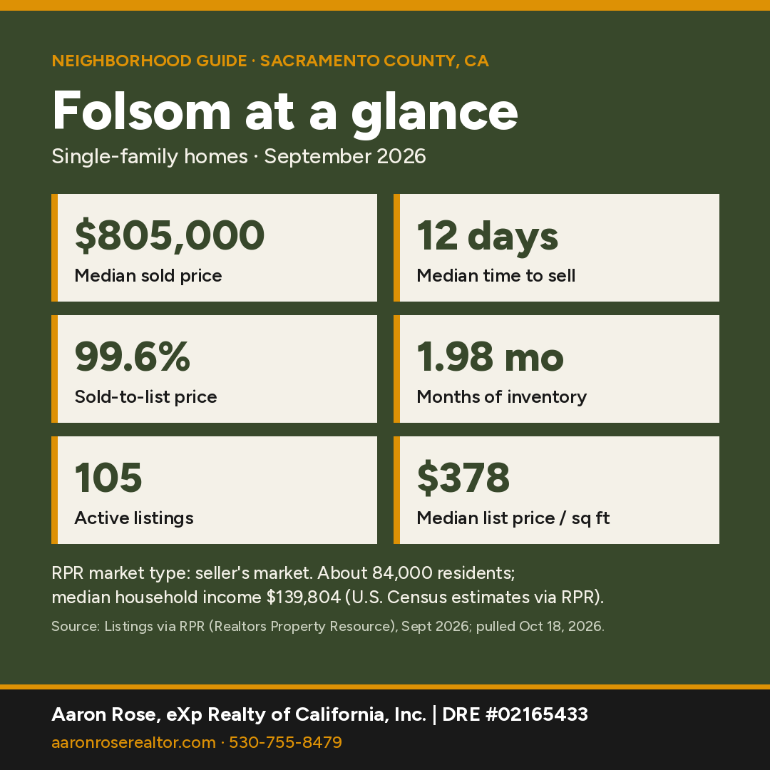
Folsom at a glance
Sources: market figures, single-family homes, Listings via RPR, Sept 2026, pulled Oct 18, 2026; income and commute, U.S. Census estimates via RPR, pulled Oct 18, 2026.
Where is Folsom, California?
Folsom is a city in northeastern Sacramento County at about 325 feet, on the American River. Downtown Sacramento is about 20 miles away (straight-line), and the El Dorado County line runs along the city's eastern side. The 2020 Census counted 80,454 residents and 29,574 housing units on 27.9 square miles of land, up 11% from 72,203 in 2010. Highway 50 crosses the southern part of the city.
County and ZIP: The city is entirely in Sacramento County. Nearly all of it is ZIP 95630 (74,787 residents across the whole ZIP area, 2020 Census). The Folsom State Prison area uses 95671 (Represa), and a point we sampled in the newer plan area south of Highway 50 fell in 95683. Nearby El Dorado Hills is a separate community in El Dorado County. ZIP areas here are Census ZCTAs, which approximate USPS ZIP codes; a mailing city name doesn't always match city limits.
Who lives here: Census estimates reported by RPR put the median age at 41 and the median household income at $139,804, and about 70% of homes are owner-occupied (U.S. Census via RPR, pulled October 18, 2026).

What is the history of Folsom?
Per the City of Folsom, the town grew from the Leidesdorff estate, a 35,000-acre grant bought by Captain Joseph Libbey Folsom. Theodore Judah laid out a townsite called Granite City. Folsom died in July 1855, and his executors renamed the town for him. The townsite was recorded in December 1855.
Judah also engineered the Sacramento Valley Railroad, which made its first run on February 22, 1856, over 22 miles from Sacramento. The city calls it the first commercial railroad west of the Rockies, and the California State Library marks the run as California's first railroad. The city says light rail now follows much of the old route. Folsom was also the western terminus of the Pony Express for a time, and the city incorporated in 1946.
Folsom State Prison received its first 44 inmates on July 26, 1880, per CDCR. Folsom Dam created Folsom Lake in the mid-1950s. The city dates construction to 1948–1955, and the Bureau of Reclamation lists completion in 1956 and a capacity of about 977,000 acre-feet.

The Folsom Powerhouse
On July 13, 1895, the Folsom Powerhouse sent electricity 22 miles to Sacramento at 11,000 volts, per California State Parks. The agency calls the 1895 plant one of the oldest hydroelectric facilities in the world and a prototype for modern electrical transmission. It's now Folsom Powerhouse State Historic Park (9980 Greenback Ln.).

What are Folsom's main neighborhoods?
Historic District: Sutter Street and the blocks around it hold the Gold Rush and railroad-era downtown, including the Folsom History Museum (823 Sutter St.). Expect older homes and some historic properties nearby.
North of Highway 50: The city's established neighborhoods are north of the freeway, around Lake Natoma and Folsom Lake. RPR puts the city's median home age at 26 years. The area south of the freeway was annexed only after 2004.
Folsom Plan Area (south of Highway 50): In 2004 voters approved Measure W, which allowed the city to annex about 3,520 acres south of Highway 50. It required a new water supply and 30% natural open space, per the city. This is where most of Folsom's newest homes are being built, and builders market much of it as Folsom Ranch.

What is there to do in and around Folsom?
Folsom Lake State Recreation Area wraps around Folsom Lake and Lake Natoma, with day-use areas such as Beals Point, Folsom Point and Nimbus Flat, plus trails along both lakes, per State Parks. The historic Rainbow Bridge crosses the American River near the Historic District. South of Highway 50, the city's Measure W plan calls for more than 1,000 acres of protected open space and over 30 miles of bike paths and trails as the Plan Area builds out.
What schools serve Folsom?
Census/NCES boundaries put essentially all of the city in Folsom Cordova Unified School District; one sampled point on the far western edge fell in San Juan Unified. NCES lists FCUSD's Folsom High, Vista del Lago High and Folsom Lake High (1655 Iron Point Rd.), plus Folsom Middle, Sutter Middle and many elementaries. The city's Plan Area documents call for five new elementary schools, a middle school and a high school south of Highway 50 as neighborhoods fill in.
How local schools rate in RPR (school ratings shown in Realtors Property Resource, pulled October 18, 2026):
- Vista del Lago High: A+
- Folsom High: A+
- Folsom Preparatory School (private, K–5): A+
- Gold Ridge Elementary: A
- Sutter Middle: A
- Oak Chan Elementary: A
- Blanche Sprentz Elementary: A-
Ratings are third-party summaries, and district lines don't follow ZIP codes or community names, so confirm the district and school assignment for a specific address with the Sacramento County Office of Education or the district office.
How far is Folsom from Sacramento?
Folsom is about 20 miles (straight-line) from downtown Sacramento via Highway 50, and SacRT light rail serves the city. Census estimates reported by RPR put the average commute at about 27 minutes.
Highway 50 runs west to Sacramento and east toward El Dorado Hills and Lake Tahoe (South Lake Tahoe is about 65 miles, straight-line). Roseville is about 12 miles northwest, and Sacramento International Airport about 24 miles. Drive times vary by address and traffic, so ask Aaron for a route check from a specific property.
Thinking about buying in Folsom?
With a median price around $805,000 and homes going in about 12 days, a pre-qualification letter helps you move fast when the right house lists. It's free, with no obligation.
Get Pre-QualifiedWhat are home prices in Folsom right now?
The median sold price for a single-family home in Folsom was $805,000 in September 2026, about 4.5% higher than a year earlier. Homes sold at 99.6% of list price after a median of 12 days, and the median sold home had about 2,064 square feet (Listings via RPR, pulled October 18, 2026).
Supply is tight. RPR showed 105 active listings (median list price $799,000, or $378 per square foot; median 34 days on market), 82 new listings and 32 pending sales in September, against 59 closed sales. That works out to 1.98 months of inventory, which RPR classifies as a seller's market. RPR's median estimated home value for the city is $807,110, up 1.2% over 12 months (public records and listings via RPR).
One month of single-family sales is a small sample, so ask Aaron for numbers on a specific neighborhood or price range.
Own in Folsom? See what it's worth.
Buyers are moving quickly. Get a free, no-obligation value estimate for your home.
See What It's WorthHow does Folsom compare with nearby towns?
| Town | Median sold | Sold in Sept | Median days | Months supply | Sold-to-list |
|---|---|---|---|---|---|
| Folsom | $805,000 | 59 | 12 | 1.98 | 99.6% |
| El Dorado Hills | $985,000 | 55 | 26 | 2.87 | 98.6% |
| Granite Bay | $1,225,000 | 17 | 48 | 3.11 | 96.7% |
| Roseville | $627,303 | 114 | 27 | 2.30 | 99.3% |
| Rancho Cordova | $566,164 | 57 | 30 | 3.15 | 99.5% |
| Orangevale | $516,000 | 15 | 16 | 1.53 | 99.9% |
Single-family homes, September 2026. Source: Listings via RPR, Sept 2026, pulled Oct 18, 2026. Year-over-year changes are omitted for comparison towns. Small towns such as Granite Bay and Orangevale had fewer than 20 sales, so their medians can swing month to month.
In short: Granite Bay's median runs about $420,000 above Folsom's; El Dorado Hills, across the county line, runs about $180,000 higher. Roseville and Rancho Cordova offer more homes for less money, and Orangevale was the only one tighter than Folsom on supply. See all Northern California neighborhood guides.
Things every buyer should know in Folsom
Fire hazard zones and insurance
The State Fire Marshal released updated Fire Hazard Severity Zone maps for local-responsibility areas in 2025, and the City of Folsom adopted its map by Ordinance No. 1350 on May 13, 2025. Our check of the state's recommended map data (March 2025) against the city boundary found Moderate zones covering roughly a quarter of the city's area and no High or Very High zones inside city limits. California's defensible-space documentation rule for home sales (Civil Code §1102.19) applies to homes in High or Very High zones, so on this map it generally wouldn't apply inside city limits, but confirm your zone on the CAL FIRE viewer and in the Natural Hazard Disclosure. Insurance availability and price vary by carrier and address, so request quotes early in escrow; the California Department of Insurance has consumer guides.
HOA dues and Mello-Roos (CFD) taxes
Most of the Folsom Plan Area sits in City of Folsom Community Facilities District No. 18, a Mello-Roos district that pays for backbone water, sewer, roads, trails and park maintenance. Some neighborhoods are also in additional districts, such as CFD No. 23 (Folsom Ranch). A September 24, 2024 city staff report projected the total property tax for developed homes in CFD No. 18 at about 1.49% to 1.81% of the estimated sale price, capped at 2.0%. The city refers parcel questions to NBS at 800-676-7516. HOA dues vary by subdivision, so read the CC&Rs, budget and reserve study during your contingency period.
Flood zones
Folsom sits below Folsom Dam, but most flood-zone questions here are about local creeks. FEMA issued preliminary updated flood maps for Folsom and Sacramento County in 2022, revising hazards along the Willow/Humbug basin and Alder Creek tributaries, among others. Look up any address on the FEMA Flood Map Service Center. Federally regulated lenders require flood insurance for homes in a mapped Special Flood Hazard Area (A zones).
New construction south of Highway 50
CFD No. 18 covers about 3,520 acres bounded by Highway 50, White Rock Road, Prairie City Road and the El Dorado County line, planned for 13,343 homes plus shops, offices, schools and 1,114.5 acres of open space (city staff report, September 2024). Expect phased parks and schools, builder contracts that differ from resale contracts, and the tax rates above. Bring your own agent to your first model-home visit.
Water
The City of Folsom gets all of its drinking water from Folsom Lake, and the city notes that groundwater isn't readily available because Folsom sits mostly on granite. Its water rights date to 1851, and the city holds water supply contracts for 34,000 acre-feet from Folsom Lake. Neighborhoods north of the American River get wholesale water through San Juan Water District, and small portions of the city are served by Orange Vale Water Company. Measure W required a separate supply for the Plan Area, which the city met with conserved water validated by a court decree. Check which agency serves a specific address.
Nearby communities
All Northern California guides →
Folsom FAQ
What is the median home price in Folsom?
The median sold price for single-family homes in Folsom was $805,000 in September 2026, about 4.5% higher than a year earlier, with homes selling in a median of 12 days at 99.6% of list price (Listings via RPR, pulled October 18, 2026).
What county is Folsom in?
Sacramento County. The city lies entirely within it, next to the El Dorado County line.
What is the population of Folsom, CA?
80,454 residents and 29,574 housing units at the 2020 U.S. Census, up from 72,203 in 2010. Recent Census estimates reported by RPR put it at about 84,000.
What ZIP codes cover Folsom?
Mostly 95630. The prison area uses 95671 (Represa), and part of the area south of Highway 50 may use 95683. Check city limits for a specific address.
What school district serves Folsom?
Census/NCES boundaries place essentially all of the city in Folsom Cordova Unified School District, which runs Folsom High, Vista del Lago High and Folsom Lake High. Confirm by address.
Is Folsom in a fire hazard severity zone?
Parts of it. The 2025 state map Folsom adopted on May 13, 2025 shows Moderate zones in the city, and our check of the state's map data found no High or Very High zones inside city limits. Confirm any address on the CAL FIRE viewer.
Do homes in Folsom Ranch have Mello-Roos taxes?
Generally yes. The Folsom Plan Area is in Mello-Roos district CFD No. 18, and a September 2024 city staff report projected total property tax there at about 1.49% to 1.81% of the sale price, capped at 2.0%. Get the exact parcel amount before you write an offer.
Is Folsom in El Dorado Hills?
No. Folsom is a city in Sacramento County. El Dorado Hills is an unincorporated community across the county line in El Dorado County.
What is the Folsom Powerhouse?
An 1895 hydroelectric plant that sent power 22 miles to Sacramento, now Folsom Powerhouse State Historic Park.
Let's find your place in Folsom.
Whether you're buying, selling or comparing Folsom with nearby towns, Aaron can pull current numbers for a specific neighborhood and walk you through the trade-offs.
Contact AaronCall 530-755-8479See Recent SalesSources & Photo Credits (35)
- Realtors Property Resource (RPR): Folsom, El Dorado Hills, Granite Bay, Roseville, Rancho Cordova and Orangevale market activity (single-family, Sept 2026), Census-based demographics and school ratings, pulled Oct 18, 2026
- TIGERweb 2020 and 2010 Incorporated Places layers (population, housing units, land area)
- Census ZCTA-to-county relationship file, 2020
- Census geocoder grid sampling inside the 2020 city boundary (ZIP and school district checks)
- USGS elevation
- NCES EDGE 2023-24 public school locations within the city boundary
- Sacramento County Office of Education
- City of Folsom: history
- City of Folsom: railroad legacy
- California State Library: first railroad
- CDCR: Folsom Prison history
- U.S. Bureau of Reclamation: Folsom Dam
- California State Parks: Folsom Powerhouse SHP brochure
- California State Parks: Folsom Lake SRA brochure
- City of Folsom: Folsom Plan Area history (Measure W)
- City of Folsom: Folsom Plan Area fact sheet (open space, trails, planned schools)
- Folsom History Museum
- City of Folsom: 2025 Fire Hazard Severity Zones (LRA map dated March 10, 2025)
- City of Folsom City Clerk: Ordinance No. 1350, adopted May 13, 2025
- CAL FIRE/OSFM LRA FHSZ data (recommended March 24, 2025), intersected with the 2020 Census city boundary on Oct 18, 2026
- CAL FIRE Fire Hazard Severity Zone Viewer for real estate
- California Civil Code §1102.19 (defensible-space documentation at sale)
- City of Folsom staff report, Sept 24, 2024: CFD No. 18 Series 2024 bonds
- City of Folsom staff report: CFD No. 23 (Folsom Ranch)
- City of Folsom: Mello-Roos and special assessment districts (NBS contact)
- City of Folsom: FEMA flood map update, Sept 29, 2022
- FEMA Flood Map Service Center
- City of Folsom: Folsom Water Vision (water source, rights, contracts)
- City of Folsom: Plan Area water supply
- San Juan Water District: wholesale customers (Folsom north of Lake Natoma, Orange Vale Water Co.)
Photos (hosted by Wikimedia Commons; Creative Commons as credited):
- UncleVinny · CC BY 3.0: Folsom History Museum Sutter Street - panoramio.jpg
- Arkyan · CC BY-SA 3.0: Sacramento County ... Folsom Highlighted.svg
- Noah_Loverbear · CC BY-SA 3.0: Folsom Dam Folsom Lake CA. - panoramio.jpg
- zschmeez · CC BY-SA 3.0: Folsom Powerhouse.JPG
- UncleVinny · CC BY 3.0: Rainbow Bridge Folsom California 997 - panoramio.jpg
Facts were checked against the sources above in October 2026. Market figures are single-family, one month, and change monthly. Distances are straight-line.
Aaron Rose, REALTOR® | DRE #02165433 | eXp Realty of California, Inc. | Broker DRE #01878277 | 530-755-8479 · aaron.rose@exprealty.com. Market data: Listings via RPR (Realtors Property Resource), single-family homes, September 2026, pulled October 18, 2026. Information is deemed reliable but not guaranteed and may change; buyers should independently verify all information, including county, ZIP, school district, hazard zones and property details for a specific address. Equal Housing Opportunity. Last updated October 18, 2026.
For Sale
- 1/84 84
 Open Thu 3PM-5PM
$ 2,300,000
4 Beds5 Baths4,490 SqFt324 Tobrurry WAY, Folsom, CA 95630
Single Family Home
Listed by eXp Realty of California Inc.

- 3D
 New
$ 800,000
4 Beds3 Baths2,515 SqFt110 Conductor WAY, Folsom, CA 95630
Single Family Home
Listed by eXp Realty of California Inc.
- 3D
 Active
$ 565,000
3 Beds2 Baths1,437 SqFt40 American River Canyon DR, Folsom, CA 95630
Multi-Family
Listed by eXp Realty of California Inc.
- 1/33 33
 Active
$ 679,000
4 Beds3 Baths1,832 SqFt3332 Auburn Leaf LOOP, Folsom, CA 95630
Single Family Home
Listed by eXp Realty of California Inc.
- 1/60 60
 Active
$ 1,020,000
4 Beds3 Baths2,662 SqFt4336 Hummingbird CIR, Folsom, CA 95630
Single Family Home
Listed by eXp Realty of California Inc.
- 1/41 41
 Price Dropped by $20K
$ 649,000
3 Beds3 Baths1,705 SqFt4782 Cantrell DR, Folsom, CA 95630
Single Family Home
Listed by eXp Realty of California Inc.
- 1/99 99
 Price Dropped by $40K
$ 1,759,000
5 Beds5 Baths4,559 SqFt14873 Amber Grove CT, Folsom, CA 95630
Single Family Home
Listed by eXp Realty of California Inc.
- 3D
 Active
$ 2,950,000
4 Beds6 Baths6,189 SqFt455 Serpa WAY, Folsom, CA 95630
Single Family Home
Listed by eXp Realty of California Inc.
- 1/36 36
 Price Dropped by $10K
$ 594,900
3 Beds3 Baths1,573 SqFt703 Ward WAY, Folsom, CA 95630
Single Family Home
Listed by eXp Realty of California Inc.
- 3D
 Price Dropped by $25K
$ 625,000
4 Beds3 Baths2,143 SqFt1708 N Parkway DR, Folsom, CA 95630
Single Family Home
Listed by eXp Realty of California Inc.
- 1/87 87
 Price Dropped by $16K
$ 759,000
4 Beds3 Baths2,154 SqFt3270 Garden Terrace DR, Folsom, CA 95630
Single Family Home
Listed by eXp Realty of California Inc.
- 3D
 Price Dropped by $25K
$ 1,049,999
4 Beds3 Baths2,657 SqFt117 Oak Rock CIR, Folsom, CA 95630
Single Family Home
Listed by eXp Realty of California Inc.
- 1/36 36
 Active
$ 495,000
2 Beds2 Baths1,130 SqFt244 Caples DR, Folsom, CA 95630
Single Family Home
Listed by eXp Realty of California Inc.
- 1/60 60
 Price Dropped by $24K
$ 875,000
4 Beds3 Baths2,463 SqFt5125 Silent Grove DR, Folsom, CA 95630
Single Family Home
Listed by eXp Realty of California Inc.
- 1/52 52
 Price Dropped by $50K
$ 799,000
3 Beds2 Baths1,602 SqFt711 1/2 Sibley ST, Folsom, CA 95630
Multi-Family
Listed by eXp Realty of California Inc.
- 1/43 43
 Price Dropped by $19K
$ 824,990
5 Beds4 Baths2,825 SqFt1433 Cummings WAY, Folsom, CA 95630
Single Family Home
Listed by eXp Realty of California Inc.
- 1/34 34
 Price Dropped by $15K
$ 80,000
2 Beds2 Baths1,344 SqFt75 Redwood LN, Folsom, CA 95630
Manufactured Home
Listed by eXp Realty of California Inc.
- 1/20 20
 Active
$ 254,900
0.29 Acres145 Hopfield DR, Folsom, CA 95630
Vacant Land
Listed by eXp Realty of California Inc.
- 1/57 57
 Open Sat 1PM-3PM
$ 759,000
4 Beds3 Baths1,997 SqFt421 Amhurst CIR, Folsom, CA 95630
Single Family Home
Listed by Vista Sotheby's International Realty
- 1/75 75
 Open Tue 10AM-12PM
$ 1,299,000
4 Beds3 Baths4,135 SqFt340 Water View WAY, Folsom, CA 95630
Single Family Home
Listed by eXp Realty of Northern California, Inc.
- 1/92 92
 Open Sat 12PM-3PM
$ 1,699,000
6 Beds6 Baths4,242 SqFt4729 Iron Bird DR, Folsom, CA 95630
Single Family Home
Listed by Nick Sadek Sotheby's International Realty
- 1/44 44
 Open Sat 11AM-2PM
$ 929,000
5 Beds3 Baths2,682 SqFt112 Gisler Ct, Folsom, CA 95630
Single Family Home
Listed by Real Brokerage Technologies, Inc.
- 1/31 31
 New
$ 134,900
2 Beds1 Bath812 SqFt55 BIRCH LN, Folsom, CA 95630
Manufactured Home
Listed by Newpoint Realty
- 1/77 77
 New
$ 1,479,000
5 Beds5 Baths3,927 SqFt1669 Bowen DR, Folsom, CA 95630
Single Family Home
Listed by Miller Real Estate
- 1/27 27
 New
$ 888,000
4 Beds2 Baths2,244 SqFt356 Silberhorn DR, Folsom, CA 95630
Single Family Home
Listed by Excel Realty
- 1/52 52
 New
$ 859,000
3 Beds2 Baths2,206 SqFt208 Ruth CT, Folsom, CA 95630
Single Family Home
Listed by Real Broker Technologies
- 1/79 79
 New
$ 885,000
4 Beds3 Baths2,075 SqFt230 Briggs Ranch DR, Folsom, CA 95630
Single Family Home
Listed by Windermere Signature Properties El Dorado Hills/Folsom
- 1/60 60
 New
$ 849,000
3 Beds3 Baths1,831 SqFt101 Gold Mine CT, Folsom, CA 95630
Single Family Home
Listed by Keller Williams Realty
- 1/34 34
 New
$ 124,900
2 Beds2 Baths720 SqFt166 Pinebrook DR, Folsom, CA 95630
Manufactured Home
Listed by RE/MAX Gold Folsom
- 1/58 58
 New
$ 839,900
4 Beds3 Baths2,259 SqFt1123 Burwick LN, Folsom, CA 95630
Single Family Home
Listed by HomeSmart ICARE Realty
RECENTLY SOLD
Image
Address
Sold Date
Property Type
Configuration
Price

1337 Blough WAY, Folsom, CA 95630
Single Family Home
5 Beds3 Baths3,327 SqFt
$ 1,027,500 $ 1,100,000 6.6%
Listed by Realty ONE Group Complete

4631 Valley Terrace CIR, Folsom, CA 95630
Single Family Home
4 Beds4 Baths3,467 SqFt
$ 1,350,000 $ 1,449,000 6.8%
Listed by eXp Realty of California Inc.

715 Figueroa ST, Folsom, CA 95630
Single Family Home
3 Beds2 Baths1,719 SqFt
$ 995,000 $ 995,000
Listed by eXp Realty of California Inc.

150 Perry CT, Folsom, CA 95630
Single Family Home
5 Beds3 Baths3,022 SqFt
$ 1,100,000 $ 1,050,000 4.8%
Listed by eXp Realty of California Inc.

3324 Crooked Bed WAY, Folsom, CA 95630
Single Family Home
5 Beds3 Baths2,995 SqFt
$ 840,000 $ 849,000 1.1%
Listed by eXp Realty of California Inc

4603 Scenic Vista DR, Folsom, CA 95630
Single Family Home
4 Beds3 Baths2,713 SqFt
$ 1,027,000 $ 1,075,000 4.5%
Listed by eXp Realty of California Inc.
housing detail

Coming Soon
Listing Detail
Commute Score
Coming Soon
demographics
Population
Density
Households
Gender
Coming Soon
Education
Coming Soon
Coming Soon
Coming Soon
Nearby Locations
324 Tobrurry WAY, Folsom, CA 95630
4 Beds 5 Baths 4,490 SqFt
Single Family Home
Listed by eXp Realty of California Inc.
110 Conductor WAY, Folsom, CA 95630
4 Beds 3 Baths 2,515 SqFt
Single Family Home
Listed by eXp Realty of California Inc.40 American River Canyon DR, Folsom, CA 95630
3 Beds 2 Baths 1,437 SqFt
Multi-Family
Listed by eXp Realty of California Inc.3332 Auburn Leaf LOOP, Folsom, CA 95630
4 Beds 3 Baths 1,832 SqFt
Single Family Home
Listed by eXp Realty of California Inc.4336 Hummingbird CIR, Folsom, CA 95630
4 Beds 3 Baths 2,662 SqFt
Single Family Home
Listed by eXp Realty of California Inc.3249 Wildland CT, Folsom, CA 95630
5 Beds 5 Baths 2,953 SqFt
Single Family Home
Listed by eXp Realty of California Inc.4782 Cantrell DR, Folsom, CA 95630
3 Beds 3 Baths 1,705 SqFt
Single Family Home
Listed by eXp Realty of California Inc.14873 Amber Grove CT, Folsom, CA 95630
5 Beds 5 Baths 4,559 SqFt
Single Family Home
Listed by eXp Realty of California Inc.455 Serpa WAY, Folsom, CA 95630
4 Beds 6 Baths 6,189 SqFt
Single Family Home
Listed by eXp Realty of California Inc.9544 Central AVE, Folsom, CA 95630
3 Beds 2 Baths 1,359 SqFt
Single Family Home
Listed by eXp Realty of California Inc.703 Ward WAY, Folsom, CA 95630
3 Beds 3 Baths 1,573 SqFt
Single Family Home
Listed by eXp Realty of California Inc.1708 N Parkway DR, Folsom, CA 95630
4 Beds 3 Baths 2,143 SqFt
Single Family Home
Listed by eXp Realty of California Inc.3270 Garden Terrace DR, Folsom, CA 95630
4 Beds 3 Baths 2,154 SqFt
Single Family Home
Listed by eXp Realty of California Inc.306 Turn Pike Drive, Folsom, CA 95630
3 Beds 3 Baths 2,214 SqFt
Single Family Home
Listed by eXp Realty of California Inc.1021 Kirby CT, Folsom, CA 95630
4 Beds 3 Baths 2,231 SqFt
Single Family Home
Listed by eXp Realty of California Inc.117 Oak Rock CIR, Folsom, CA 95630
4 Beds 3 Baths 2,657 SqFt
Single Family Home
Listed by eXp Realty of California Inc.244 Caples DR, Folsom, CA 95630
2 Beds 2 Baths 1,130 SqFt
Single Family Home
Listed by eXp Realty of California Inc.5125 Silent Grove DR, Folsom, CA 95630
4 Beds 3 Baths 2,463 SqFt
Single Family Home
Listed by eXp Realty of California Inc.711 1/2 Sibley ST, Folsom, CA 95630
3 Beds 2 Baths 1,602 SqFt
Multi-Family
Listed by eXp Realty of California Inc.1433 Cummings WAY, Folsom, CA 95630
5 Beds 4 Baths 2,825 SqFt
Single Family Home
Listed by eXp Realty of California Inc.
MARKET TRENDS

GET MORE INFORMATION