
CA
Oroville
Sacramento Valley City Guide · Butte County
Oroville, California
Oroville is the Butte County seat, with 20,042 residents (2020 Census), where the Feather River leaves the foothills for the Sacramento Valley at about 180 feet.
Explore the full Oroville neighborhood guideHide the full Oroville guide

Sacramento Valley City Guide · Butte County
Oroville, California
The Butte County seat on the Feather River, below Lake Oroville and the tallest dam in the United States
Entrance area of the Oroville Chinese Temple (1863), California Historical Landmark No. 770. Image: Frank Schulenburg · CC BY-SA 4.0
The short answer
What is it like to live in Oroville?
Oroville is the Butte County seat, with 20,042 residents (2020 Census), where the Feather River leaves the foothills for the Sacramento Valley at about 180 feet. It's known for its Gold Rush and Chinese heritage downtown and for Lake Oroville and Oroville Dam, at 770 feet the tallest dam in the U.S., just upstream.
- County: Butte County (county seat)
- Population: 20,042 residents, 7,705 housing units (2020 Census)
- ZIP: 95965 and 95966
- Elevation: About 180 ft
- Schools: Oroville City Elementary or Thermalito Union (small Palermo Union area), all feeding Oroville Union High
- Nearest city: About 22 miles (straight-line) southeast of Chico; about 63 miles north of Sacramento
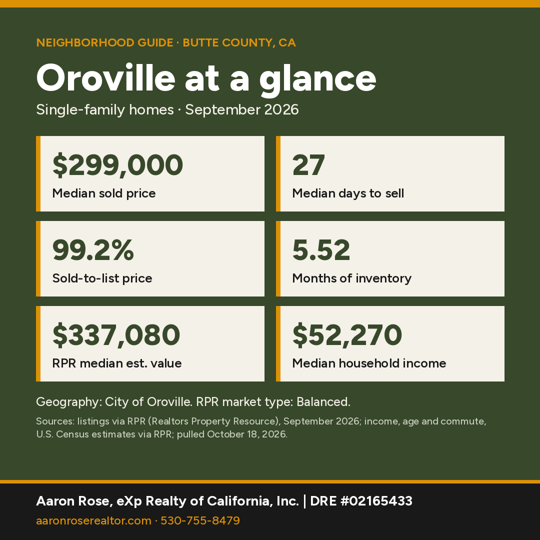
Oroville at a glance
Sources: market figures, City of Oroville, single-family, Sept 2026 (RPR); income, age and commute, U.S. Census estimates for the City of Oroville via RPR, pulled October 18, 2026.
Where is Oroville, California?
Oroville is the county seat of Butte County. It sits where the Feather River leaves the Sierra foothills for the Sacramento Valley, about 22 miles (straight-line) southeast of Chico and 63 miles north of downtown Sacramento, at roughly 180 feet elevation. The 2020 Census counted 20,042 residents and 7,705 housing units on 13.8 square miles of land, up from 15,546 in 2010. Just upstream, Oroville Dam holds back Lake Oroville.
Much of greater Oroville lies outside city limits. The unincorporated Thermalito (7,198), Oroville East (8,038), Palermo (5,555) and South Oroville (3,235) CDPs together had more residents in 2020 than the city itself.
County and ZIP: The city lies entirely in Butte County. It's split between ZIP 95965 (21,548 residents across the whole ZIP area) and 95966 (31,591). 95965 is entirely in Butte County. 95966 is about 97% Butte by land, with a sliver in Yuba County. Both reach far beyond the city, so check city limits for any address.

What is the history of Oroville?
Per the Butte County Historical Society, gold was found in 1849 at a camp first called Ophir. When the town applied for a post office in 1854, it took the name Oroville because several other California places already used a version of Ophir. Voters moved the county seat from Bidwell Bar to Oroville in 1856. By the end of 1858 Oroville had nearly 4,000 people and was the state's fifth-largest town, per the society. A CSU Chico county history says the first town government asked the Legislature to disincorporate it in 1859 because of its tax burden. The present city was incorporated in 1906 (January 3, per the Library of Congress name record).

Chinese miners and merchants made Oroville one of the largest Chinese communities in the north state. The state landmark plaque says the Chinese Temple (1500 Broderick St.) was dedicated in the spring of 1863 to serve 10,000 Chinese then living here, and that Chinese residents deeded it to the city in 1935. It is California Historical Landmark No. 770 and on the National Register (#76000478).
On August 29, 1911, a Yahi man later known as Ishi was found by butchers at a corral in Oroville. The site is California Historical Landmark No. 809. Anthropologists from UC Berkeley took him to San Francisco, where he helped them document Yahi culture, per the Office of Historic Preservation.
What are Oroville's main neighborhoods?
Historic downtown: The old commercial core includes Montgomery and Myers Streets. Its anchor is the State Theatre (1489 Myers St.), designed by Timothy Pflueger and opened April 7, 1928. The city bought it in 1983, and a nonprofit guild now runs it as a performing arts center.


Olive Highway corridor: State Route 162 (Olive Highway) runs east from downtown toward the dam and Kelly Ridge. Oroville Hospital (2767 Olive Hwy.) is inside city limits along this corridor.
Thermalito and the west side: West of the Feather River, the city borders the unincorporated Thermalito area. Parts of the city here fall in the Thermalito Union School District (see Schools).
Unincorporated surroundings: Oroville East, Kelly Ridge and Palermo add hillside, lake-view and rural properties with Oroville mailing addresses.
Lake Oroville & the Feather River
Per the California Department of Water Resources, Oroville Dam is the tallest dam in the United States at 770 feet. DWR's facts handout says it is 43.6 feet taller than Hoover Dam. Lake Oroville is the largest reservoir in the State Water Project and the second-largest in California, holding about 3.54 million acre-feet, with 167 miles of shoreline when full. The embankment was topped out in 1967.

In February 2017, damage to the dam's spillways led to an evacuation order for Oroville and downstream communities. Cal OES estimates about 188,000 people evacuated. Two days later it was reduced to an evacuation watch, and Cal OES says the main spillway was fully reconstructed in 2018.

Inside the city, the Feather River Fish Hatchery (5 Table Mountain Blvd.) raises Chinook salmon and steelhead. CDFW says its underwater viewing window shows migrating fish from about mid-September through June, and the Oroville Salmon Festival is held on the fourth Saturday of September. DWR's Lake Oroville Visitor Center is on Kelly Ridge, east of the city.
What schools serve Oroville?
Oroville's school map is split. Under Census/NCES EDGE boundaries, most points we sampled inside the city fall in Oroville City Elementary School District. A large share on the west side falls in Thermalito Union School District, and one southern point falls in Palermo Union. All of those feed Oroville Union High School District. One far-western point near the municipal airport falls in Biggs Unified. NCES lists schools inside city limits such as Oroville High (1535 Bridge St.), Ishi Hills Middle, Stanford Avenue Elementary, Nelson Avenue Middle and Plumas Avenue Elementary. Butte College's main campus (3536 Butte Campus Dr.) has an Oroville address but lies outside the city, in the Butte Valley CDP. District lines don't follow ZIP codes or community names, so buyers should confirm the district and school assignment for a specific address with the Butte County Office of Education or the district office.
How local schools rate in RPR (school ratings in Realtors Property Resource for the City of Oroville, pulled October 18, 2026):
- Stream Charter School (Elementary, Middle): B+
- Oroville High School (High): B-
- Plumas Avenue Elementary School (Elementary): C+
- The Studios @ Central Middle School (Middle): C
- Nelson Avenue Middle School (Middle): C
- Ishi Hills Middle School (Middle): C
- Ipakanni Early College Charter School (Elementary, Middle, High): C
Ratings are third-party summaries, and district lines don't follow ZIP codes or community names, so confirm the school assignment for a specific address with the district office.
How far is Oroville from Sacramento?
Oroville is about 63 miles (straight-line) north of downtown Sacramento and about 22 miles southeast of Chico; State Route 70 runs south toward Marysville and Sacramento.
State Route 70 runs south toward Marysville (about 24 miles straight-line) and Sacramento (about 63 miles). Route 162 heads east toward the lake and west across the valley. Chico is about 22 miles away. Drive times vary by address, so ask Aaron for a route check from a specific property.
Census estimates for the City of Oroville reported by RPR put the average travel time to work at about 20 minutes.
Thinking about buying in Oroville?
With a median sold price around $299,000 (City of Oroville), a pre-qualification letter shows sellers you're ready and helps you move fast when the right home lists. It's free, with no obligation.
Get Pre-QualifiedWhat are homes like in Oroville?
Inside the city, expect older homes near downtown and the river, mid-century neighborhoods, and newer subdivisions on the edges. Rural, lake-view and acreage properties are mostly in the unincorporated areas around the city. Flood-zone status, wildfire risk and insurance are standard due-diligence items here.
Home prices right now
The median sold price for a single-family home in Oroville was $299,000 in September 2026. Homes sold at 99.2% of list price after a median of 27 days (17 closed sales).
RPR showed 182 active listings (median list price $350,000, or $229 per square foot), 56 new listings and 40 pending sales in September 2026. That works out to 5.52 months of inventory, which RPR classifies as a balanced market. RPR's median estimated home value is $337,080, up 1.7% over 12 months.
Small markets have few sales each month, so medians can swing; ask Aaron for numbers on a specific area or price range.
Who lives here: Census estimates for the City of Oroville reported by RPR put the population at about 20,000, the median age at 36, median household income at $52,270 and owner-occupied homes at 53% (U.S. Census via RPR, pulled October 18, 2026).
Geography: City of Oroville, single-family, Sept 2026 (RPR). Source: listings and public records via RPR (Realtors Property Resource); pulled October 18, 2026.
Own in Oroville? See what it's worth.
Get a free, no-obligation value estimate for your home.
See What It's WorthHow does Oroville compare with nearby towns?
| Town | Median sold | Sold in month | Median days | Months supply | Sold-to-list |
|---|---|---|---|---|---|
| Oroville | $299,000 | 17 | 27 | 5.52 | 99.2% |
| Forbestown Butte County figures |
$417,500 | 87 | 29 | 4.03 | 99% |
| Marysville only 4 sales |
Too few sales | 4 | Too few sales | 4.71 | Too few sales |
| Yuba City | $450,000 | 26 | 26 | 3.36 | 99.1% |
| Loma Rica Yuba County figures |
$470,000 | 49 | 35 | 3.84 | 100% |
Single-family homes, September 2026. Source: listings via RPR (Realtors Property Resource), pulled October 18, 2026. Where a town had too few sales of its own, its row uses the ZIP code or county shown under its name. "Too few sales" means RPR reported no figure, or the town had under 5 sales, too few for a meaningful median. Towns with few sales can swing month to month.
See all Northern California neighborhood guides.
Things every buyer should know in Oroville
Fire hazard zones and insurance
Oroville is mostly a Local Responsibility Area (the city provides fire protection). Our check of the state's 2025 LRA map against the 2020 Census city boundary found Very High under 1%, High ≈9%, Moderate ≈25% of city area, plus non-wildland (unzoned) areas; small edges fall in the State Responsibility Area (High under 1%). Percentages are approximate. Because High and Very High zones are mapped here, check the defensible-space rule for sales (Civil Code §1102.19): for a home in one of those zones, the seller must give the buyer documentation of compliance where a local ordinance requires it, or, where a government or qualified nonprofit agency offers inspections, documentation from an inspection in the six months before the sale. If the seller hasn't obtained it, buyer and seller sign a written agreement for the buyer to get it (within one year after closing where no local ordinance applies). Ask the local fire agency which applies. Wildfire exposure affects homeowners insurance availability and price. Get quotes during your inspection period, not after; if the standard market declines, the California FAIR Plan is the state's insurer of last resort and is usually paired with a separate difference-in-conditions policy. Confirm any parcel on the CAL FIRE viewer and in the Natural Hazard Disclosure.
Flood zones
Our check of FEMA's National Flood Hazard Layer across the 2020 Census boundary found about 5% in a mapped Special Flood Hazard Area (zones A, AE, AO), which can include creek, river and lake surfaces. Look up any address on the FEMA Flood Map Service Center. Federally regulated lenders require flood insurance for homes in a mapped Special Flood Hazard Area (A or AE zones).
Water
Oroville has several water providers: the Cal Water Oroville District (treated Feather River water plus wells), South Feather Water & Power Agency (Oroville, Palermo and Bangor areas) and Thermalito Water and Sewer District. Check each agency's service-area map for a specific address.
Wells and septic
Homes in unincorporated areas around Oroville often use wells and septic. Rural Butte County homes generally use private wells and septic. Butte County Environmental Health permits onsite wastewater systems (site evaluation with soil test holes, then a construction permit) and requires a permit to build, repair, deepen or destroy a well. Ask for the septic permit and pumping history, and get a well flow and water-quality test during escrow.
Internet
Check providers and speeds for a specific address on the CPUC California Interactive Broadband Map.
Nearby communities
All Northern California guides →
Oroville FAQ
What is the median home price in Oroville?
The median sold price for single-family homes in Oroville was $299,000 in September 2026, with a median of 27 days to sell (City of Oroville, single-family, listings via RPR).
What county is Oroville in?
Oroville is the county seat of Butte County, California, and lies entirely within it.
How tall is Oroville Dam?
770 feet. Per the California Department of Water Resources, it is the tallest dam in the United States.
What ZIP codes cover Oroville?
The city is split between 95965 and 95966. Both ZIPs extend well beyond city limits, so check whether a specific address is inside the city.
What school districts serve Oroville?
Census/NCES boundaries split the city between Oroville City Elementary and Thermalito Union (with a small Palermo Union area), feeding Oroville Union High School District. Confirm by address.
What is the Oroville Chinese Temple?
A temple dedicated in 1863 at 1500 Broderick Street, deeded to the City of Oroville in 1935. It is California Historical Landmark No. 770 and on the National Register.
What is the population of Oroville?
20,042 residents and 7,705 housing units at the 2020 U.S. Census, up from 15,546 in 2010.
What kind of homes are in Oroville?
Inside the city, expect older homes near downtown and the river, mid-century neighborhoods, and newer subdivisions on the edges. Rural, lake-view and acreage properties are mostly in the unincorporated areas around the city.
Is Oroville in a fire hazard severity zone?
Oroville is mostly a Local Responsibility Area (the city provides fire protection). Our check of the state's 2025 LRA map against the 2020 Census city boundary found Very High under 1%, High ≈9%, Moderate ≈25% of city area, plus non-wildland (unzoned) areas; small edges fall in the State Responsibility Area (High under 1%). Percentages are approximate. Because High and Very High zones are mapped here, check the defensible-space rule for sales (Civil Code §1102.19): for a home in one of those zones, the seller must give the buyer documentation of compliance where a local ordinance requires it, or, where a government or qualified nonprofit agency offers inspections, documentation from an inspection in the six months before the sale. If the seller hasn't obtained it, buyer and seller sign a written agreement for the buyer to get it (within one year after closing where no local ordinance applies). Ask the local fire agency which applies. Confirm any address on the CAL FIRE viewer.
Let's find your place in Oroville.
Whether you're buying, selling or comparing Oroville with nearby towns, Aaron can pull current numbers for a specific area and walk you through the trade-offs.
Contact AaronCall 530-755-8479See Recent SalesSources & Photo Credits (50)
- Realtors Property Resource (RPR): Oroville and comparison-town market activity, Census-based demographics and school ratings
- TIGERweb 2020 Incorporated Places layer (POP100, HU100, AREALAND)
- TIGERweb Census 2010 Incorporated Places layer
- https://www2.census.gov/geo/docs/maps-data/data/rel2020/zcta520/tab20_zcta520_county20_natl.txt
- Census geocoder 9×9 grid sampling inside the 2020 city boundary
- https://epqs.nationalmap.gov/ (USGS elevation)
- NCES EDGE 2023-24 public school locations within the city boundary (polygon query)
- https://tigerweb.geo.census.gov/arcgis/rest/services/TIGERweb/Transportation/MapServer (TIGER road names)
- TIGERweb 2020 Census Designated Places / Incorporated Places layers (POP100)
- Census geocoder address lookups (city/CDP containing each listed address)
- https://www.bcoe.org/ (Butte County Office of Education)
- https://buttecountyhistory.com/wp-content/uploads/2022/02/Oroville.pdf (Butte County Historical Society)
- http://archives.csuchico.edu/digital/api/collection/coll14/id/3965/download (History of Butte County, CSU Chico digital collections)
- https://www.orovilleca.gov/205/How-Local-Government-Works (City of Oroville)
- https://id.loc.gov/authorities/names/n81081023.html (Library of Congress name authority, Jan. 3, 1906 incorporation)
- https://ohp.parks.ca.gov/ListedResources/Detail/770 (CHL 770, Chinese Temple)
- https://npgallery.nps.gov/AssetDetail/NRIS/76000478 (NRHP #76000478)
- https://ohp.parks.ca.gov/ListedResources/Detail/809 (CHL 809, Discovery Site of the Last Yahi Indian)
- https://water.ca.gov/Programs/State-Water-Project/SWP-Facilities/Oroville (California DWR)
- https://cwc.ca.gov/-/media/CWC-Website/Files/Documents/2023/09_September/September2023_Items_7_8_Attach_1_OrovilleHandout.pdf (DWR Oroville facts handout, California Water Commission)
- https://www.usbr.gov/lc/hooverdam/history/essays/biggest.html (U.S. Bureau of Reclamation)
- https://news.caloes.ca.gov/cal-oes-revisits-the-oroville-dam-spillway-incident-and-its-impacts-five-years-later/ (Cal OES, 2022)
- https://wildlife.ca.gov/fishing/hatcheries/feather-river (CDFW, Feather River Fish Hatchery)
- https://water.ca.gov/Programs/Integrated-Science-and-Engineering/Feather-River-Program (DWR Feather River Program)
- https://www.orovillestatetheater.com/about (State Theater Arts Guild)
- https://www.butte.edu/locations/main-campus/ (Butte College)
- https://www.orovillehospital.com/contact-us/ (Oroville Hospital)
- https://water.ca.gov/OrovilleRecreation (DWR Lake Oroville Recreation; via search snippet, page blocked to our fetcher)
- California Civil Code §1102.19 (defensible-space documentation at sale; text verified Oct 18, 2026)
- CPUC California Interactive Broadband Map
- Butte County Environmental Health: Wastewater Program
- Butte County Water Well Ordinance (Ch. 23B)
- Cal Water: Oroville District
- California Department of Insurance: residential insurance consumer resources
- California Department of Insurance: California FAIR Plan
- CAL FIRE/OSFM Local Responsibility Area FHSZ data (FHSZLRA25_v1, 2025), intersected with the 2020 Census city boundary on Oct 18, 2026
- CAL FIRE/OSFM State Responsibility Area FHSZ data (FHSZSRA_23_3, effective April 1, 2024), intersected with the 2020 Census place boundary or town point on Oct 18, 2026
- FEMA Flood Map Service Center
- FEMA National Flood Hazard Layer (flood hazard zones), intersected Oct 18, 2026
- South Feather Water & Power Agency: service area map
- Cal Water: Oroville District service area map (2024)
- Thermalito Water and Sewer District: service area map
- CAL FIRE Fire Hazard Severity Zone Viewer
Photos (hosted by Wikimedia Commons; public domain or Creative Commons as credited):
- Frank Schulenburg · CC BY-SA 4.0: Oroville Chinese Temple, October 2020-4018.jpg
- Arkyan · CC BY-SA 3.0: Butte County California Incorporated and Unincorporated areas Oroville Highlighted.svg
- Podruznik · Public domain: Historic downtown oroville.jpg
- Frank Schulenburg · CC BY-SA 4.0: Buildings on Montgomery Street in Oroville (2023)-L1004147.jpg
- Frank Schulenburg · CC BY-SA 4.0: Oroville State Theatre (2023)-L1004160.jpg
- California Department of Water Resources · Public domain: OrovilleDam.jpg
- Carol M. Highsmith, Library of Congress · Public domain: View of Lake Oroville, a reservoir above the city of Oroville created by the damming of the Feather River LCCN2013631180.tif
Facts were checked against the sources above in October 2026. Market figures are single-family, one month, and change monthly. Hazard-zone percentages are our approximate GIS overlays; confirm by address. Distances are straight-line.
Aaron Rose, REALTOR® | DRE #02165433 | eXp Realty of California, Inc. | Broker DRE #01878277 | 530-755-8479 · aaron.rose@exprealty.com. Market data: listings via RPR (Realtors Property Resource), single-family homes. Information is deemed reliable but not guaranteed and may change; buyers should independently verify all information, including county, ZIP, school district, hazard zones and property details for a specific address. Equal Housing Opportunity. Last updated October 18, 2026.
For Sale
- 1/38 38
 Active
$ 325,000
3 Beds2 Baths1,597 SqFt69 Lariat LOOP, Oroville, CA 95966
Single Family Home
Listed by eXp Realty of California Inc.

- 1/6 6
 Active
$ 125,000
9.95 Acres0 Dutch DR, Oroville, CA 95965
Vacant Land
Listed by eXp Realty of California Inc.
- 1/6 6
 Active
$ 154,000
10 Acres50 District Center DR, Oroville, CA 95966
Vacant Land
Listed by eXp Realty of California Inc.
- 1/11 11
 Active
$ 159,000
10 Acres0 Maple Lane, Oroville, CA 95966
Vacant Land
Listed by eXp Realty of California Inc.
- 1/8 8
 Active
$ 44,900
0.27 Acres0 Oroview Dr, Oroville, CA 95965
Vacant Land
Listed by eXp Realty of California Inc.
- 1/46 46
 New
$ 383,000
1 Bed1 Bath855 SqFt534 Middlefork Lane, Oroville, CA 95966
Manufactured Home
Listed by Intero Real Estate Services
- 1/39 39
 New
$ 189,000
2 Beds1 Bath908 SqFt960 High ST, Oroville, CA 95965
Single Family Home
Listed by Parkway Real Estate Co
- 1/69 69
 Active
$ 419,000
3 Beds3 Baths1,719 SqFt1220 18th ST, Oroville, CA 95965
Single Family Home
Listed by Better Homes Realty
- 1/7 7
 Active
$ 9,995
2 Beds2 Baths500 SqFt3415 Oro Dam Blvd. E #114, Oroville, CA 95966
Manufactured Home
Listed by Reliant Realty
- 1/43 43
 Active
$ 280,000
4 Beds3 Baths2,217 SqFt2730 Orange AVE, Oroville, CA 95966
Single Family Home
Listed by American DreamWorks Realty
- 1/54 54
 Active
$ 419,900
3 Beds2 Baths1,885 SqFt127 Eagle Vista DR, Oroville, CA 95966
Single Family Home
Listed by Grand Realty Group
- 1/22 22
 Price Dropped by $15K
$ 270,000
2 Beds1 Bath879 SqFt4831 Virginia AVE, Oroville, CA 95966
Single Family Home
Listed by Nick Sadek Sotheby's International Realty
- 1/36 36
 Active
$ 225,000
3 Beds2 Baths1,685 SqFt1350 2nd Avenue, Oroville, CA 95965
Single Family Home
Listed by Realty Of America
- 1/47 47
 Price Dropped by $6K
$ 329,000
3 Beds2 Baths1,284 SqFt1080 Butte AVE, Oroville, CA 95965
Single Family Home
Listed by Nikos Krohn Realty
- 1/50 50
 Active
$ 872,000
3 Beds2 Baths2,043 SqFt294 Butte Vista Rd, Oroville, CA 95966
Single Family Home
Listed by Better Homes Realty
- 1/47 47
 Active
$ 299,800
2 Beds2 Baths1,436 SqFt2430 McClellan AVE, Oroville, CA 95966
Single Family Home
Listed by Coldwell Banker Select Real Estate
- 1/35 35
 Active
$ 438,000
3 Beds3 Baths1,844 SqFt1800 Boynton AVE, Oroville, CA 95966
Single Family Home
Listed by Go West Realty
- 1/25 25
 Price Dropped by $8K
$ 336,000
2 Beds1 Bath460 SqFt191 Black Tail RD, Oroville, CA 95966
Manufactured Home
Listed by Pinnacle Realty Advisors
- 1/40 40
 Active
$ 225,000
2 Beds2 Baths1,328 SqFt2663 Chaise DR, Oroville, CA 95966
Manufactured Home
Listed by Jason Mitchell Real Estate CA Inc.
- 1/28 28
 Price Dropped by $6K
$ 28,500
1 Bed1 Bath672 SqFt703 W Oro Dam BLVD #123, Oroville, CA 95965
Manufactured Home
Listed by Century 21 Select Real Estate
- 1/26 26
 Active
$ 579,000
4 Beds3 Baths2,905 SqFt1420 Mount Ida RD, Oroville, CA 95966
Single Family Home
Listed by Golden River Realty
- 1/7 7
 Price Dropped by $15K
$ 165,000
1 Bed1 Bath732 SqFt5135 Miners Ranch RD, Oroville, CA 95966
Single Family Home
Listed by Better Homes Realty
- 1/49 49
 Price Dropped by $15K
$ 470,000
4 Beds3 Baths2,230 SqFt240 Canyon Highlands DR, Oroville, CA 95966
Single Family Home
Listed by Industrious Realty
- 1/9 9
 Price Dropped by $15K
$ 170,000
1 Bed1 Bath500 SqFt46 Willow Creek DR, Oroville, CA 95966
Single Family Home
Listed by Better Homes Realty
- 1/61 61
 Active
$ 299,000
2 Beds2 Baths1,680 SqFt2454 Oro Quincy Hwy, Oroville, CA 95966
Single Family Home
Listed by Black Bird Realty
- 1/44 44
 Active
$ 480,000
2 Beds2 Baths1,568 SqFt49 Drescher Tract, Oroville, CA 95966
Manufactured Home
Listed by American Home Finance & Lending
- 1/72 72
 Active
$ 299,000
2 Beds2 Baths1,715 SqFt1958 Lumpkin RD, Oroville, CA 95966
Single Family Home
Listed by eXp Realty of Northern California, Inc.
- 1/49 49
 Price Dropped by $20K
$ 275,000
3 Beds2 Baths1,230 SqFt11605 Miller Peak RD, Oroville, CA 95965
Manufactured Home
Listed by RE/MAX Gold Elk Grove
- 1/14 14
 Price Dropped by $5K
$ 289,900
2 Beds2 Baths900 SqFt339 Kelly Ridge RD, Oroville, CA 95966
Single Family Home
Listed by Jared English, Broker
- 1/63 63
 Price Dropped by $20K
$ 279,500
3 Beds1 Bath1,461 SqFt4525 Olive HWY, Oroville, CA 95966
Single Family Home
Listed by Better Homes Realty
RECENTLY SOLD
Image
Address
Sold Date
Property Type
Configuration
Price

2940 Oro Quincy HWY, Oroville, CA 95966
Single Family Home
5 Beds5 Baths2,631 SqFt
$ 487,500 $ 500,000 2.5%
Listed by eXp Realty of California Inc.

16 Harbor CT, Oroville, CA 95966
Manufactured Home
3 Beds2 Baths1,590 SqFt
$ 260,000 $ 259,900
Listed by eXp Realty of California Inc.

10110 Palermo Honcut HWY, Oroville, CA 95966
Single Family Home
3 Beds3 Baths1,632 SqFt
$ 355,000 $ 375,000 5.3%
Listed by eXp Realty of California Inc.

665 Grand, Oroville, CA 95965
Manufactured Home
3 Beds2 Baths1,056 SqFt
$ 219,000 $ 219,000
Listed by eXp Realty of California Inc.

3378 Oro Bangor HWY, Oroville, CA 95966
Single Family Home
3 Beds1 Bath1,215 SqFt
$ 193,903 $ 199,900 3.0%
Listed by All City Homes

1278 12th ST, Oroville, CA 95965
Single Family Home
4 Beds2 Baths1,472 SqFt
$ 370,000 $ 359,900 2.8%
Listed by eXp Realty of California Inc.
housing detail

Coming Soon
Listing Detail
Commute Score
Coming Soon
demographics
Population
Density
Households
Gender
Coming Soon
Education
Coming Soon
Coming Soon
Coming Soon
Nearby Locations
69 Lariat LOOP, Oroville, CA 95966
3 Beds 2 Baths 1,597 SqFt
Single Family Home
Listed by eXp Realty of California Inc.
31 Dack, Oroville, CA 95966
3 Beds 2 Baths 1,560 SqFt
Single Family Home
Listed by eXp Realty of California Inc.55 Pine Oaks RD, Oroville, CA 95966
3 Beds 2 Baths 1,879 SqFt
Single Family Home
Listed by eXp Realty of California Inc.174 Hope LN, Oroville, CA 95966
6 Beds 4 Baths 1,488 SqFt
Multi-Family
Listed by eXp Realty of California Inc.0 Dutch DR, Oroville, CA 95965
9.95 Acres
Vacant Land
Listed by eXp Realty of California Inc.50 District Center DR, Oroville, CA 95966
10 Acres
Vacant Land
Listed by eXp Realty of California Inc.0 Maple Lane, Oroville, CA 95966
10 Acres
Vacant Land
Listed by eXp Realty of California Inc.0 Oroview Dr, Oroville, CA 95965
0.27 Acres
Vacant Land
Listed by eXp Realty of California Inc.3182 Claremont DR, Oroville, CA 95966
4 Beds 2 Baths 1,777 SqFt
Single Family Home
Listed by Century 21 Select Real Estate534 Middlefork Lane, Oroville, CA 95966
1 Bed 1 Bath 855 SqFt
Manufactured Home
Listed by Intero Real Estate Services960 High ST, Oroville, CA 95965
2 Beds 1 Bath 908 SqFt
Single Family Home
Listed by Parkway Real Estate Co645 Dunstone Dr, Oroville, CA 95966
4 Beds 3 Baths 3,035 SqFt
Single Family Home
Listed by Better Homes Realty1220 18th ST, Oroville, CA 95965
3 Beds 3 Baths 1,719 SqFt
Single Family Home
Listed by Better Homes Realty3415 Oro Dam Blvd. E #114, Oroville, CA 95966
2 Beds 2 Baths 500 SqFt
Manufactured Home
Listed by Reliant Realty2730 Orange AVE, Oroville, CA 95966
4 Beds 3 Baths 2,217 SqFt
Single Family Home
Listed by American DreamWorks Realty127 Eagle Vista DR, Oroville, CA 95966
3 Beds 2 Baths 1,885 SqFt
Single Family Home
Listed by Grand Realty Group100 Ridgeview LN, Oroville, CA 95966
2 Beds 2 Baths 1,500 SqFt
Single Family Home
Listed by Century 21 Cornerstone Realty4831 Virginia AVE, Oroville, CA 95966
2 Beds 1 Bath 879 SqFt
Single Family Home
Listed by Nick Sadek Sotheby's International Realty1350 2nd Avenue, Oroville, CA 95965
3 Beds 2 Baths 1,685 SqFt
Single Family Home
Listed by Realty Of America1080 Butte AVE, Oroville, CA 95965
3 Beds 2 Baths 1,284 SqFt
Single Family Home
Listed by Nikos Krohn Realty
MARKET TRENDS


GET MORE INFORMATION