
CA
Strawberry Valley
Foothill Area Guide · Yuba County
Strawberry Valley, California
Strawberry Valley is a tiny mountain hamlet in northeastern Yuba County, at about 3,750 feet on La Porte Road and roughly 39 miles (straight-line) northeast of Marysville.
Explore the full Strawberry Valley neighborhood guideHide the full Strawberry Valley guide

Foothill Area Guide · Yuba County
Strawberry Valley, California
A high-country Yuba County hamlet on the old road to La Porte
"Strawberry Valley, North East Tp., Yuba Co.", from the 1879 History of Yuba County. Image: Thompson & West, 1879 (Internet Archive Book Images) · Public domain
The short answer
What is it like to live in Strawberry Valley?
Strawberry Valley is a tiny mountain hamlet in northeastern Yuba County, at about 3,750 feet on La Porte Road and roughly 39 miles (straight-line) northeast of Marysville. Life here means mixed-conifer forest, quiet, a wood stove and real winter weather, with Little Grass Valley Recreation Area up the road near La Porte.
- County: Yuba County (town center; the Butte County line is just west)
- Population: No official count (not a CDP); the whole 95981 ZIP had 191 residents (2020 Census)
- ZIP: 95981 (shared with La Porte)
- Elevation: About 3,750 ft
- Schools: Marysville Joint Unified (nearest school: Yuba Feather Elementary in Challenge)
- Nearest city: About 39 miles (straight-line) northeast of Marysville
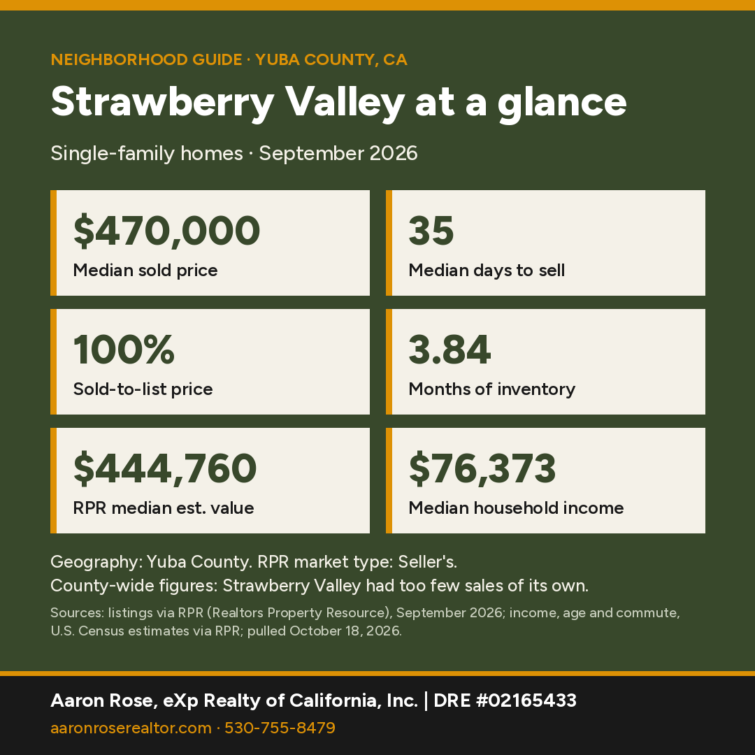
Strawberry Valley at a glance
Sources: market figures, Yuba County, single-family, Sept 2026 (RPR); income, age and commute, U.S. Census estimates for Yuba County via RPR, pulled October 18, 2026.
Strawberry Valley had too few single-family sales of its own, so the market figures here are for all of Yuba County, not Strawberry Valley specifically.
Where is Strawberry Valley, California?
Strawberry Valley is a small unincorporated community in northeastern Yuba County, at about 3,750 feet on La Porte Road (County Road E-21), about 39 miles (straight-line) northeast of Marysville. It is not a Census-designated place, so the Census reports no population for the hamlet itself.
County and ZIP: The town center is in Yuba County, with the Butte County line just to the west. Census points less than a mile west fall in Butte County, and the 1879 county history described the valley as "on the Butte county line." Strawberry Valley's ZIP 95981 also serves La Porte. It crosses into Plumas County, with about 76% of its land in Plumas and 24% in Yuba. The whole ZIP area counted just 191 residents and 341 housing units in 2020. Check the county for any parcel.
What is the history of Strawberry Valley?
The 1879 History of Yuba County (Thompson & West) calls Strawberry Valley "the most thriving locality in North East Township," forty-three miles from Marysville by road. It says Captain William Mock named it early in 1851 for the wild strawberry vines at the head of the valley. Men from Columbus, Ohio built the Columbus House hotel, rich diggings were found on Deadwood Creek, and the town had three stores by 1854. David Durham's California's Geographic Names dates the post office to 1855 and records a competing story that the name came from two settlers named Straw and Berry.
What is there to do in and around Strawberry Valley?
Strawberry Valley sits in mixed-conifer forest high on the ridge between the North Yuba and the Feather River's South Fork. It's a place for quiet, a wood stove, and real winter weather. La Porte Road continues northeast about 10 miles (straight-line) to La Porte and Plumas National Forest's Little Grass Valley Recreation Area. There the Forest Service runs 8 campgrounds (about 323 sites), three boat launches, two swim beaches and a 13-mile Lakeshore Trail, usually open mid-June to fall.

What schools serve Strawberry Valley?
Census/NCES EDGE boundaries place Strawberry Valley in Marysville Joint Unified School District. NCES lists MJUSD's nearest school, Yuba Feather Elementary, at 18008 Oregon Hill Rd in Challenge. The Plumas County part of ZIP 95981 is in Plumas Unified School District. District lines don't follow ZIP codes or community names, so buyers should confirm the district and school assignment for a specific address with the Yuba County Office of Education's School District Locator or the district office.
Realtors Property Resource (RPR) didn't list rated schools for Strawberry Valley, so this guide doesn't show school ratings. Ask the district office which schools serve a specific address.
How far is Strawberry Valley from Marysville?
Strawberry Valley is about 39 miles (straight-line) northeast of Marysville; La Porte Road runs southwest through Clipper Mills, Challenge and Brownsville toward the valley.
La Porte Road is the lifeline. It runs southwest through Clipper Mills, Challenge and Brownsville toward Marysville, and northeast to La Porte, where the Quincy–La Porte Road continues to Quincy. This is a remote mountain commute with winter snow, so ask Aaron for a route and access check from a specific property.
Census estimates for Yuba County reported by RPR put the average travel time to work at about 32 minutes.
Thinking about buying in Strawberry Valley?
With a median sold price around $470,000 (Yuba County), a pre-qualification letter shows sellers you're ready and helps you move fast when the right home lists. It's free, with no obligation.
Get Pre-QualifiedWhat are homes like in Strawberry Valley?
Expect cabins, rural homes and timberland-adjacent acreage, often with private wells, septic systems and seasonal-access considerations.
Home prices right now
Strawberry Valley had too few single-family sales in September 2026 for RPR to report figures of its own, so the numbers below are for all of Yuba County. They describe the wider county market, not Strawberry Valley specifically.
The median sold price for a single-family home across Yuba County was $470,000 in September 2026. Homes sold at 100% of list price after a median of 35 days (49 closed sales).
RPR showed 223 active listings (median list price $459,900, or $267 per square foot), 85 new listings and 51 pending sales in September 2026. That works out to 3.84 months of inventory, which RPR classifies as a seller's market. RPR's median estimated home value is $444,760, up 2.7% over 12 months.
Small markets have few sales each month, so medians can swing; ask Aaron for numbers on a specific area or price range.
Who lives here: Census estimates for Yuba County reported by RPR put the median age at 34, median household income at $76,373 and owner-occupied homes at 64% (U.S. Census via RPR, pulled October 18, 2026).
Geography: Yuba County, single-family, Sept 2026 (RPR). Source: listings and public records via RPR (Realtors Property Resource); pulled October 18, 2026.
Own in Strawberry Valley? See what it's worth.
Get a free, no-obligation value estimate for your home.
See What It's WorthHow does Strawberry Valley compare with nearby towns?
| Town | Median sold | Sold in month | Median days | Months supply | Sold-to-list |
|---|---|---|---|---|---|
| Strawberry Valley Yuba County figures |
$470,000 | 49 | 35 | 3.84 | 100% |
| La Porte Plumas County figures |
$524,500 | 46 | 80 | 9.92 | 94.5% |
| Forbestown Butte County figures |
$417,500 | 87 | 29 | 4.03 | 99% |
| Brownsville ZIP 95919 |
Too few sales | Fewer than 3 | Too few sales | 5 | Too few sales |
Single-family homes, September 2026. Source: listings via RPR (Realtors Property Resource), pulled October 18, 2026. Where a town had too few sales of its own, its row uses the ZIP code or county shown under its name. "Too few sales" means RPR reported no figure, or the town had under 5 sales, too few for a meaningful median. Towns with few sales can swing month to month.
See all Northern California neighborhood guides.
Things every buyer should know in Strawberry Valley
Fire hazard zones and insurance
Strawberry Valley isn't a Census-mapped place, so we checked the town-center point: it sits in the State Responsibility Area (CAL FIRE is responsible for wildland fire protection), mapped Very High Fire Hazard Severity Zone, with Very High zones within about 2 miles. Because High and Very High zones are mapped here, check the defensible-space rule for sales (Civil Code §1102.19): for a home in one of those zones, the seller must give the buyer documentation of compliance where a local ordinance requires it, or, where a government or qualified nonprofit agency offers inspections, documentation from an inspection in the six months before the sale. If the seller hasn't obtained it, buyer and seller sign a written agreement for the buyer to get it (within one year after closing where no local ordinance applies). Ask the local fire agency which applies. Wildfire exposure affects homeowners insurance availability and price. Get quotes during your inspection period, not after; if the standard market declines, the California FAIR Plan is the state's insurer of last resort and is usually paired with a separate difference-in-conditions policy. Ask about roof age, ember-resistant vents, clearance and the distance to the nearest fire station and hydrant or water source, since carriers price on those. Confirm any parcel on the CAL FIRE viewer and in the Natural Hazard Disclosure.
Wells and septic
Outside the cities, most homes use a private well and an onsite septic system (OWTS). Yuba County Environmental Health permits septic construction and repair under Ordinance Code 7.07: standard systems need 48 inches of effective soil, and sites that don't qualify need an alternative design. Alternative/advanced systems carry an annual operating permit and a recorded right-of-entry agreement. Ask the seller for the septic permit and pumping records, and budget for a septic inspection and a well yield and water-quality test.
Road maintenance
Many rural roads here are private. Yuba County uses County Service Areas (CSAs), funded by property-owner assessments, to maintain roads in some subdivisions; Yuba LAFCo counted 44 CSAs, most serving privately maintained roads. Before you buy, confirm whether the access road is county-maintained, in a CSA, or private, and get any recorded road-maintenance agreement.
Internet and power
Broadband varies road by road in the foothills: some addresses have cable or fiber, others rely on fixed wireless, satellite or DSL. Check the exact address on the CPUC California Interactive Broadband Map and ask the seller what they use. Rural lines can be affected by utility power shutoffs during high fire danger, so many owners keep a generator; ask about one.
Animals and agricultural zoning
Yuba County's Development Code (§11.32.050) sets animal limits by zone and parcel size. One animal unit equals one horse or cow, two pigs, four sheep or goats, or 20 poultry or rabbits; enclosures must sit 50 feet from neighboring homes and 100 feet from wells and year-round waterways. Within the Valley Growth Boundary, residential zones allow 1 unit per acre with caps. Check the parcel's zoning before you bring horses or livestock.
Flood zones
Our check of FEMA's National Flood Hazard Layer across a 1.5 km circle around the town center found little or no mapped Special Flood Hazard Area. Look up any address on the FEMA Flood Map Service Center. Federally regulated lenders require flood insurance for homes in a mapped Special Flood Hazard Area (A or AE zones).
Nearby communities
All Northern California guides →
Strawberry Valley FAQ
What is the median home price in Strawberry Valley?
Strawberry Valley had too few sales of its own, so this is the Yuba County-wide figure. The median sold price for single-family homes across Yuba County was $470,000 in September 2026, with a median of 35 days to sell (Yuba County, single-family, listings via RPR).
Where is Strawberry Valley, California?
Strawberry Valley is an unincorporated mountain community in northeastern Yuba County on La Porte Road, about 39 miles (straight-line) northeast of Marysville, at roughly 3,750 feet.
Is Strawberry Valley in Yuba, Butte or Plumas County?
The community is in Yuba County, right next to the Butte County line. Its 95981 ZIP code extends into Plumas County around La Porte, so verify the county for each parcel.
What is the population of Strawberry Valley?
Strawberry Valley is not a Census-designated place, so there is no official count. The whole 95981 ZIP area, including La Porte, had 191 residents in 2020.
What school district serves Strawberry Valley?
Census/NCES boundaries place Strawberry Valley in Marysville Joint Unified School District; the nearest MJUSD school is Yuba Feather Elementary in Challenge. Confirm by address.
How did Strawberry Valley get its name?
Per the 1879 History of Yuba County, Captain William Mock named it in 1851 for wild strawberry vines. Another story credits two settlers named Straw and Berry.
What is near Strawberry Valley?
La Porte and Plumas National Forest's Little Grass Valley Recreation Area, with campgrounds, boating, swimming and a 13-mile lakeshore trail, lie up La Porte Road to the northeast.
Is Strawberry Valley good for cabins or acreage?
Expect cabins, rural homes and timberland-adjacent acreage, often with private wells, septic systems and seasonal-access considerations.
Is Strawberry Valley in a fire hazard severity zone?
Strawberry Valley isn't a Census-mapped place, so we checked the town-center point: it sits in the State Responsibility Area (CAL FIRE is responsible for wildland fire protection), mapped Very High Fire Hazard Severity Zone, with Very High zones within about 2 miles. Because High and Very High zones are mapped here, check the defensible-space rule for sales (Civil Code §1102.19): for a home in one of those zones, the seller must give the buyer documentation of compliance where a local ordinance requires it, or, where a government or qualified nonprofit agency offers inspections, documentation from an inspection in the six months before the sale. If the seller hasn't obtained it, buyer and seller sign a written agreement for the buyer to get it (within one year after closing where no local ordinance applies). Ask the local fire agency which applies. Confirm any address on the CAL FIRE viewer.
Let's find your place in Strawberry Valley.
Whether you're buying, selling or comparing Strawberry Valley with nearby towns, Aaron can pull current numbers for a specific area and walk you through the trade-offs.
Contact AaronCall 530-755-8479See Recent SalesSources & Photo Credits (29)
- Realtors Property Resource (RPR): Strawberry Valley and comparison-town market activity, Census-based demographics and school ratings
- https://www2.census.gov/geo/docs/maps-data/data/rel2020/zcta520/tab20_zcta520_county20_natl.txt
- https://geocoding.geo.census.gov/geocoder/ (county, ZCTA, CDP, school-district layers; grid sampling)
- https://tigerweb.geo.census.gov/arcgis/rest/services/TIGERweb (2020 ZCTA layer: 95981 POP100/HU100)
- https://epqs.nationalmap.gov/ (USGS elevation)
- https://nces.ed.gov/opengis/rest/services/K12_School_Locations/EDGE_GEOCODE_PUBLICSCH_2324/MapServer (NCES EDGE 2023-24 school locations)
- https://www.yubacoe.org/schools-directory/directory/school-districts
- https://tigerweb.geo.census.gov/arcgis/rest/services/TIGERweb/Transportation/MapServer (TIGER road names)
- https://www.openstreetmap.org/node/141046356 and GNIS (via Wikipedia): coordinates 39.5642,-121.1069
- https://en.localwiki.org/yuba-sutter/Strawberry_Valley (transcribes Thompson & West, History of Yuba County, 1879, North East Township)
- Durham, David L., California's Geographic Names (1998), p. 562 (via Wikipedia's citation)
- https://www.fs.usda.gov/r05/plumas/recreation/little-grass-valley-recreation-area (Plumas National Forest)
- https://www.appeal-democrat.com/plumas-highway-ready-links-quincy-and-la-porte-to-yuba-foothill-communities/article_2f9c43e8-f47e-5238-9f46-6203d3484106.html (La Porte Road / County Road E-21)
- California Civil Code §1102.19 (defensible-space documentation at sale; text verified Oct 18, 2026)
- CPUC California Interactive Broadband Map
- California Department of Insurance: residential insurance consumer resources
- California Department of Insurance: California FAIR Plan
- CAL FIRE/OSFM State Responsibility Area FHSZ data (FHSZSRA_23_3, effective April 1, 2024), intersected with the 2020 Census place boundary or town point on Oct 18, 2026
- FEMA Flood Map Service Center
- FEMA National Flood Hazard Layer (flood hazard zones), intersected Oct 18, 2026
- CAL FIRE State Responsibility Area boundaries (SRA22_2), point check Oct 18, 2026
- CAL FIRE Fire Hazard Severity Zone Viewer
- Yuba County Environmental Health: Alternative/Advanced OWTS (annual operating permit)
- Yuba County Development Code Ch. 11.32 (§11.32.050 Animal Raising and Keeping)
- Yuba County Public Works: County Service Areas (road maintenance)
- Yuba LAFCo: County Service Areas service review (2013)
- Yuba County Environmental Health: Sewage Disposal Program (Ordinance Code 7.07, OWTS Manual)
Photos (hosted by Wikimedia Commons; public domain or Creative Commons as credited):
- Thompson & West, 1879 (Internet Archive Book Images) · Public domain: History of Yuba County, California, with illustrations descriptive of its scenery, residences, public buildings, fine blocks and manufactories (1879) (14598518928).jpg
- Jonalexdeval · CC BY 3.0: Little grass valley.jpg
Facts were checked against the sources above in October 2026. Market figures are single-family, one month, and change monthly. Hazard-zone percentages are our approximate GIS overlays; confirm by address. Distances are straight-line.
Aaron Rose, REALTOR® | DRE #02165433 | eXp Realty of California, Inc. | Broker DRE #01878277 | 530-755-8479 · aaron.rose@exprealty.com. Market data: listings via RPR (Realtors Property Resource), single-family homes. Information is deemed reliable but not guaranteed and may change; buyers should independently verify all information, including county, ZIP, school district, hazard zones and property details for a specific address. Equal Housing Opportunity. Last updated October 18, 2026.
LISTINGS
- 1/10 10
 Active
$ 35,000
7.26 Acres2761 Quincy La Porte RD, Strawberry Valley, CA 95981
Vacant Land
Listed by eXp Realty of California Inc.

- 1/58 58
 Active
$ 459,000
5 Beds2 Baths2,000 SqFt1639 Onion Circle, Strawberry Valley, CA 95981
Single Family Home
Listed by Hamman Real Estate
- 1/63 63
 Active
$ 379,000
2 Beds3 Baths1,518 SqFt14138 La Porte RD, Strawberry Valley, CA 95981
Multi-Family
Listed by eXp Realty of Northern California, Inc.
RECENTLY SOLD
Image
Address
Sold Date
Property Type
Configuration
Price

2801 Quincy La Porte RD, Strawberry Valley, CA 95981
Single Family Home
464 SqFt
$ 65,000 $ 70,000 7.1%
Listed by eXp Realty of California Inc.

3005 Sprucewood LN, Strawberry Valley, CA 95981
Vacant Land
0.37 Acres
$ 8,000 $ 9,000 11.1%
Listed by eXp Realty of California Inc.

14145 La Porte RD, Strawberry Valley, CA 95981
Single Family Home
2 Beds1 Bath640 SqFt
$ 60,000 $ 69,000 13.0%
Listed by eXp Realty of Northern California, Inc.
MARKET TRENDS

housing detail

Coming Soon
Listing Detail
Nearby Locations
2761 Quincy La Porte RD, Strawberry Valley, CA 95981
7.26 Acres
Vacant Land
Listed by eXp Realty of California Inc.
1639 Onion Circle, Strawberry Valley, CA 95981
5 Beds 2 Baths 2,000 SqFt
Single Family Home
Listed by Hamman Real Estate14138 La Porte RD, Strawberry Valley, CA 95981
2 Beds 3 Baths 1,518 SqFt
Multi-Family
Listed by eXp Realty of Northern California, Inc.2780 Cedarview CT, Strawberry Valley, CA 95981
0.67 Acres
Vacant Land
Listed by eXp Realty of Northern California, Inc.
Commute Score
Coming Soon
demographics
Population
Density
Households
Gender
Coming Soon
Education
Coming Soon
Coming Soon
Coming Soon

GET MORE INFORMATION