
CA
Roseville
Sacramento Region City Guide · Placer County
Roseville, California
Roseville is Placer County's largest city, with 147,773 residents (2020 Census), on the valley floor about 16 miles (straight-line) from downtown Sacramento.
Explore the full Roseville neighborhood guideHide the full Roseville guide

Sacramento Region City Guide · Placer County
Roseville, California
A railroad junction grown into Placer County's largest city
The Vernon Street arch in downtown Roseville, 2013. Image: Noah_Loverbear · CC BY-SA 3.0
The short answer
What is it like to live in Roseville?
Roseville is Placer County's largest city, with 147,773 residents (2020 Census), on the valley floor about 16 miles (straight-line) from downtown Sacramento. It combines a railroad-town downtown and Union Pacific's huge J.R. Davis Yard with master-planned neighborhoods, the Westfield Galleria, two major hospitals and its own city-owned electric utility.
- County: Placer County
- Population: 147,773 residents, 57,318 housing units (2020 Census)
- ZIP: Mainly 95747, 95678 and 95661
- Elevation: About 150 ft
- Schools: Roseville City, Dry Creek Joint or Eureka Union elementary, all feeding Roseville Joint Union High
- Nearest city: About 16 miles (straight-line) from downtown Sacramento
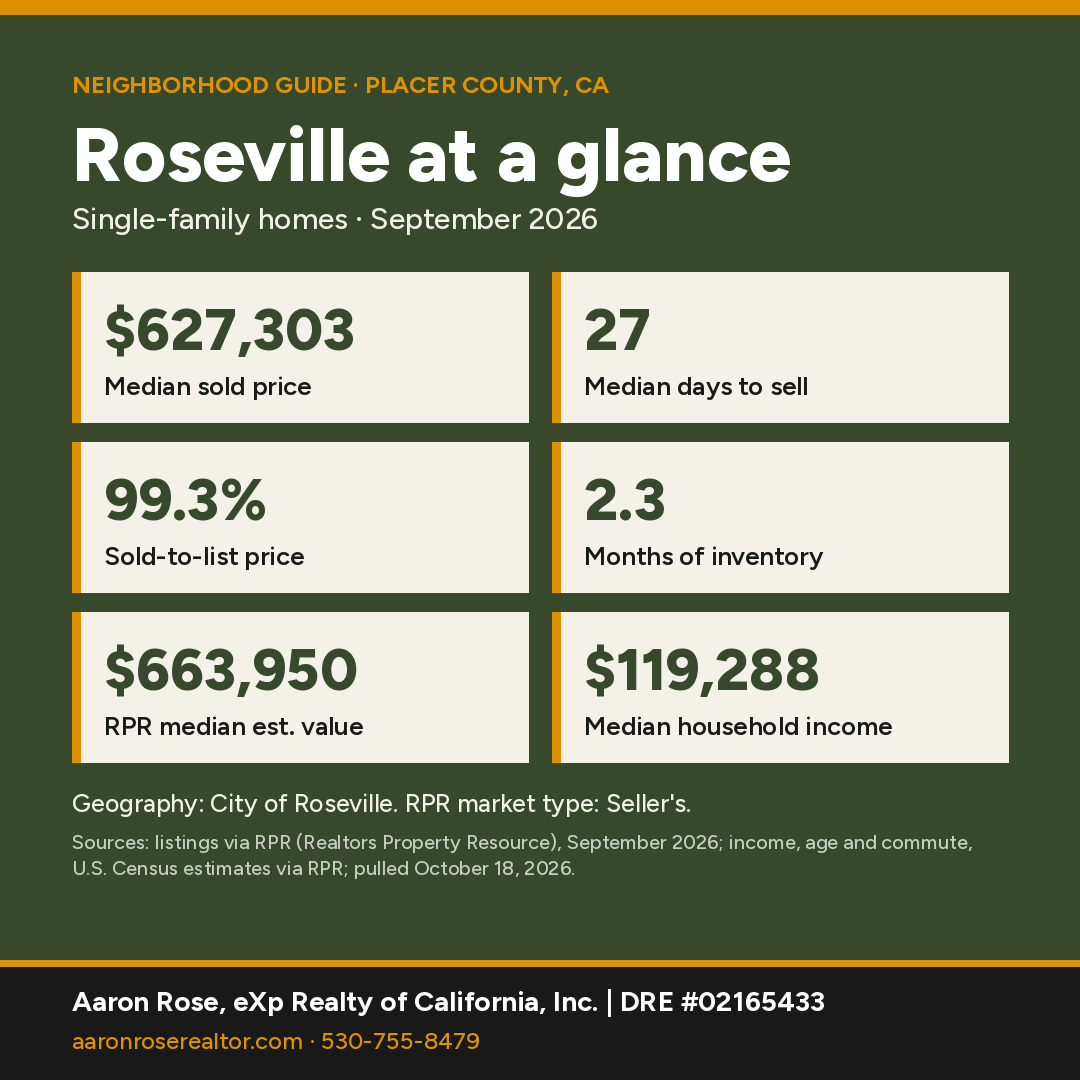
Roseville at a glance
Sources: market figures, City of Roseville, single-family, Sept 2026 (RPR); income, age and commute, U.S. Census estimates for the City of Roseville via RPR, pulled October 18, 2026.
Where is Roseville, California?
Roseville is a city in southwestern Placer County at about 150 feet, on the valley floor where Placer County meets Sacramento County. Downtown Sacramento is about 16 miles away (straight-line). The 2020 Census counted 147,773 residents and 57,318 housing units on 44.1 square miles of land, up 24% from 118,788 in 2010. That makes it Placer County's largest city by a wide margin. Interstate 80 and Highway 65 run through it, and Rocklin borders it to the northeast.
County and ZIP: The city is entirely in Placer County. Its three main ZIP areas are 95747 (west, 75,019 residents across the whole ZIP area), 95678 (45,136) and 95661 (32,847). All three are in Placer County; 95678 touches Sacramento County only along a sliver of the boundary. The far northwest edge reaches 95668 (Pleasant Grove), which straddles Placer and Sutter counties. ZIP areas here are Census ZCTAs, which approximate USPS ZIP codes; a mailing city name doesn't always match city limits.

What is the history of Roseville?
Per the city's history by Leonard "Duke" Davis, Central Pacific crews reached their crossing with the California Central Railroad at Grider's ranch on January 29, 1864. The spot was simply called "Junction." O.D. Lambard laid out a town there on August 13, 1864. Several stories explain the name Roseville; Davis calls the wild roses version the most acceptable.

The big change came when the Southern Pacific chose Roseville for its terminal and yards in early 1906. Shops and the roundhouse moved down from Rocklin between 1906 and 1908, and the town boomed. Voters approved incorporation on April 2, 1909, and the first Board of Trustees took office on April 10, 1909, per the Roseville Police Department's history.
The Rail Yard
The railroad is still part of daily life. Union Pacific's J.R. Davis Yard sits in the middle of the city. Union Pacific calls it the largest rail yard west of the Rockies, at about 950 acres, handling roughly 98% of Northern California rail traffic. A 2004 California Air Resources Board study put about two-thirds of the yard in Placer County.

What are Roseville's main neighborhoods?
Downtown and Old Town: The historic core along Vernon Street and the original railroad district holds the Odd Fellows Hall and other early commercial buildings.
Sun City Roseville: A 55+ community of 3,110 homes, per its community association, with golf and open space.
West Roseville and newer plan areas: Most recent growth is in the city's specific plan areas, per city planning pages. West Roseville (adopted 2004) covers 3,162 acres and about 8,792 units. Sierra Vista (2010) covers 2,064 acres and about 8,679 units. Amoruso Ranch (2016) covers 694 acres and about 2,827 units.
Roseville also has its own city-owned power company: Roseville Electric has served the city since 1912 and covers a 43-square-mile territory, per the city.
What amenities and hospitals are in Roseville?
The Maidu Museum & Historic Site (1970 Johnson Ranch Dr.) preserves petroglyphs and hundreds of bedrock mortars left by Nisenan Maidu people. The site was listed on the National Register of Historic Places in 1973 as the Strap Ravine Nisenan Maidu Indian Site, and the current museum opened in 2010, per the city.

Westfield Galleria at Roseville on Galleria Boulevard is the area's main regional mall. Two major hospitals are in the city: Sutter Roseville Medical Center (1 Medical Plaza Dr.) and Kaiser Permanente Roseville Medical Center (1600 Eureka Rd.).
What schools serve Roseville?
Census/NCES boundaries put most of the city in Roseville City School District for elementary and middle grades. Western neighborhoods fall in Dry Creek Joint Elementary, and a few eastern points fall in Eureka Union. All three feed the Roseville Joint Union High School District, which runs Roseville High (1 Tiger Way), Oakmont High (1710 Cirby Way), Woodcreek High and West Park High, among others. One sampled point on the far western edge fell in Center Joint Unified. District lines don't follow ZIP codes or community names, so buyers should confirm the district and school assignment for a specific address with the Placer County Office of Education or the district office.
How local schools rate in RPR (school ratings in Realtors Property Resource for the City of Roseville, pulled October 18, 2026):
- Merryhill Elementary School (private) (Elementary): A+
- St. Albans Country Day School (private) (Elementary/Middle): A+
- Woodcreek High School (High): A
- Maidu Elementary School (Elementary): A
- Olympus Junior High School (Middle): A
- Roseville High School (High): A
- Diamond Creek Elementary School (Elementary): A-
Ratings are third-party summaries, and district lines don't follow ZIP codes or community names, so confirm the school assignment for a specific address with the district office.
How far is Roseville from Sacramento?
Roseville is about 16 miles (straight-line) from downtown Sacramento via Interstate 80, and about 15.5 miles from Sacramento International Airport.
Interstate 80 runs southwest to Sacramento (about 16 miles straight-line) and northeast to Rocklin (about 4.5 miles) and Auburn (about 16 miles). Highway 65 heads north toward Lincoln. Sacramento International Airport is about 15.5 miles away, and Folsom about 12. Drive times vary by address and traffic, so ask Aaron for a route check from a specific property.
Thinking about buying in Roseville?
With a median sold price around $627,303 (City of Roseville), a pre-qualification letter shows sellers you're ready and helps you move fast when the right home lists. It's free, with no obligation.
Get Pre-QualifiedWhat are homes like in Roseville?
Expect older railroad-era homes near downtown, age-restricted homes in Sun City, and newer master-planned subdivisions in the specific plan areas, where HOA and Mello-Roos/CFD assessments are common due-diligence items. Many homes are served by Roseville Electric rather than PG&E for power.
Home prices right now
The median sold price for a single-family home in Roseville was $627,303 in September 2026. Homes sold at 99.3% of list price after a median of 27 days (114 closed sales).
RPR showed 297 active listings (median list price $675,000, or $325 per square foot), 172 new listings and 110 pending sales in September 2026. That works out to 2.3 months of inventory, which RPR classifies as a seller's market. RPR's median estimated home value is $663,950, up 1.1% over 12 months.
Small markets have few sales each month, so medians can swing; ask Aaron for numbers on a specific area or price range.
Who lives here: Census estimates for the City of Roseville reported by RPR put the population at about 156,000, the median age at 40, median household income at $119,288 and owner-occupied homes at 69% (U.S. Census via RPR, pulled October 18, 2026).
Geography: City of Roseville, single-family, Sept 2026 (RPR). Source: listings and public records via RPR (Realtors Property Resource); pulled October 18, 2026.
Own in Roseville? See what it's worth.
Get a free, no-obligation value estimate for your home.
See What It's WorthHow does Roseville compare with nearby towns?
| Town | Median sold | Sold in month | Median days | Months supply | Sold-to-list |
|---|---|---|---|---|---|
| Roseville | $627,303 | 114 | 27 | 2.3 | 99.3% |
| Rocklin | $729,500 | 44 | 29 | 2.33 | 99.2% |
| Lincoln | $634,357 | 74 | 36 | 3 | 98.8% |
| Granite Bay | $1,225,000 | 17 | 48 | 3.11 | 96.7% |
| Folsom | $805,000 | 59 | 12 | 1.98 | 99.6% |
Single-family homes, September 2026. Source: listings via RPR (Realtors Property Resource), pulled October 18, 2026. Where a town had too few sales of its own, its row uses the ZIP code or county shown under its name. "Too few sales" means RPR reported no figure, or the town had under 5 sales, too few for a meaningful median. Towns with few sales can swing month to month.
See all Northern California neighborhood guides.
Things every buyer should know in Roseville
Fire hazard zones and insurance
Roseville is mostly a Local Responsibility Area (the city provides fire protection). Our check of the state's 2025 LRA map against the 2020 Census city boundary found High under 1%, Moderate ≈17% of city area, plus non-wildland (unzoned) areas. Percentages are approximate. Wildfire exposure affects homeowners insurance availability and price. Get quotes during your inspection period, not after; if the standard market declines, the California FAIR Plan is the state's insurer of last resort and is usually paired with a separate difference-in-conditions policy. Confirm any parcel on the CAL FIRE viewer and in the Natural Hazard Disclosure.
Mello-Roos (CFD) taxes
Most newer Roseville neighborhoods are in Mello-Roos districts. The city lists services and bond CFDs including Fiddyment, Westpark, Sierra Vista, Creekview, Amoruso Ranch, Crocker Ranch, Longmeadow, Stoneridge, Westbrook and Woodcreek (services districts, bond districts). Get the parcel's exact special tax from the tax bill.
Flood zones
Our check of FEMA's National Flood Hazard Layer across the 2020 Census boundary found about 7% in a mapped Special Flood Hazard Area (zones A, AE), which can include creek, river and lake surfaces. Look up any address on the FEMA Flood Map Service Center. Federally regulated lenders require flood insurance for homes in a mapped Special Flood Hazard Area (A or AE zones).
New construction
West Roseville's specific plan areas are still building out, including Amoruso Ranch and Sierra Vista, and national builders such as Taylor Morrison list Roseville communities. Expect builder contracts and CFD taxes to review. Bring your own agent to your first model-home visit.
Internet
Check providers and speeds for a specific address on the CPUC California Interactive Broadband Map.
Watching new construction near Roseville?
Get early word on new phases, pricing and builder incentives, with your own agent on your side.
Join the New Construction VIP ListNearby communities
All Northern California guides →
Roseville FAQ
What is the median home price in Roseville?
The median sold price for single-family homes in Roseville was $627,303 in September 2026, with a median of 27 days to sell (City of Roseville, single-family, listings via RPR).
What county is Roseville in?
Placer County. The city lies entirely within it, along the Sacramento County line.
What is the population of Roseville, CA?
147,773 residents and 57,318 housing units at the 2020 U.S. Census, up from 118,788 in 2010. It is Placer County's largest city.
What ZIP codes cover Roseville?
Mainly 95747, 95678 and 95661, all in Placer County. The far northwest edge reaches 95668. Check city limits for a specific address.
What school districts serve Roseville?
Most of the city is in Roseville City School District, with western areas in Dry Creek Joint Elementary and some eastern areas in Eureka Union. All feed Roseville Joint Union High School District. Confirm by address.
Why is Roseville a railroad town?
It began in 1864 as "Junction," where two railroads crossed. The Southern Pacific moved its yards there in 1906–08, and today Union Pacific's J.R. Davis Yard covers about 950 acres.
Who provides electricity in Roseville?
Roseville Electric, a city-owned utility serving Roseville since 1912.
What kind of homes are in Roseville?
Expect older railroad-era homes near downtown, age-restricted homes in Sun City, and newer master-planned subdivisions in the specific plan areas, where HOA and Mello-Roos/CFD assessments are common.
Is Roseville in a fire hazard severity zone?
Roseville is mostly a Local Responsibility Area (the city provides fire protection). Our check of the state's 2025 LRA map against the 2020 Census city boundary found High under 1%, Moderate ≈17% of city area, plus non-wildland (unzoned) areas. Percentages are approximate. Confirm any address on the CAL FIRE viewer.
Let's find your place in Roseville.
Whether you're buying, selling or comparing Roseville with nearby towns, Aaron can pull current numbers for a specific area and walk you through the trade-offs.
Contact AaronCall 530-755-8479See Recent SalesSources & Photo Credits (42)
- Realtors Property Resource (RPR): Roseville and comparison-town market activity, Census-based demographics and school ratings
- TIGERweb 2020 Incorporated Places layer (POP100, HU100, AREALAND)
- TIGERweb Census 2010 Incorporated Places layer
- https://www2.census.gov/geo/docs/maps-data/data/rel2020/zcta520/tab20_zcta520_county20_natl.txt
- Census geocoder 9×9 grid sampling inside the 2020 city boundary
- https://epqs.nationalmap.gov/ (USGS elevation)
- NCES EDGE 2023-24 public school locations within the city boundary (polygon query)
- https://tigerweb.geo.census.gov/arcgis/rest/services/TIGERweb/Transportation/MapServer (TIGER road names)
- Census geocoder address lookups (city/CDP containing each listed address)
- https://www.placercoe.org/ (Placer County Office of Education)
- https://www.roseville.ca.gov/administration/history_of_roseville.php (City of Roseville, history by Leonard "Duke" Davis)
- https://www.roseville.ca.gov/police/about_roseville_pd/history.php (Roseville Police Department history)
- https://www.up.com/aboutup/community/community_ties/041912_roseville_tour.htm (Union Pacific)
- https://ww2.arb.ca.gov/sites/default/files/classic/diesel/documents/rrstudy/rrstudy101404.pdf (CARB Roseville Rail Yard Study, 2004)
- https://www.roseville.ca.gov/electric_utility/about_us/index.php (Roseville Electric Utility)
- https://www.roseville.ca.gov/development_services/planning/general_plan.php (City of Roseville General Plan; West Roseville, Sierra Vista and Amoruso Ranch specific plan pages)
- https://www.roseville.ca.gov/maidu_museum_historic_site/ (Maidu Museum & Historic Site, City of Roseville)
- https://cityofroseville.hosted.civiclive.com/government/departments/library/maidu_museum_historic_site/history (Maidu Museum history page)
- https://npgallery.nps.gov/AssetDetail/NRIS/73000420 (National Register of Historic Places)
- https://suncityroseville.org/ (Sun City Roseville Community Association)
- https://www.westfield.com/en/united-states/galleriaatroseville (Westfield Galleria at Roseville)
- https://www.sutterhealth.org/find-location/facility/sutter-roseville-medical-center (Sutter Roseville Medical Center)
- https://healthy.kaiserpermanente.org/northern-california/facilities/roseville-medical-center-100331 (Kaiser Permanente Roseville Medical Center; via search)
- California Civil Code §1102.19 (defensible-space documentation at sale; text verified Oct 18, 2026)
- Amoruso Ranch (Roseville) master-planned community site
- CPUC California Interactive Broadband Map
- California Department of Insurance: residential insurance consumer resources
- California Department of Insurance: California FAIR Plan
- CAL FIRE/OSFM Local Responsibility Area FHSZ data (FHSZLRA25_v1, 2025), intersected with the 2020 Census city boundary on Oct 18, 2026
- CAL FIRE/OSFM State Responsibility Area FHSZ data (FHSZSRA_23_3, effective April 1, 2024), intersected with the 2020 Census place boundary or town point on Oct 18, 2026
- FEMA Flood Map Service Center
- FEMA National Flood Hazard Layer (flood hazard zones), intersected Oct 18, 2026
- California DRE: Disclosures in Real Property Transactions (RE 6)
- City of Roseville: CFD (Mello-Roos) services districts
- City of Roseville: CFD (Mello-Roos) bond districts
- Taylor Morrison: Roseville communities
- CAL FIRE Fire Hazard Severity Zone Viewer
Photos (hosted by Wikimedia Commons; public domain or Creative Commons as credited):
- Noah_Loverbear · CC BY-SA 3.0: Vernon Street Arch In Downtown Roseville Ca. - panoramio.jpg
- Arkyan · CC BY-SA 3.0: Placer County California Incorporated and Unincorporated areas Roseville Highlighted.svg
- Publichall · CC BY-SA 4.0: Odd Fellows Hall, Roseville, California.jpg
- Sergey Yarmolyuk · CC BY-SA 4.0: Roseville Rail Yard.jpg
- Cullen328 · CC BY-SA 4.0: Maidu Museum & Historic Site.jpg
Facts were checked against the sources above in October 2026. Market figures are single-family, one month, and change monthly. Hazard-zone percentages are our approximate GIS overlays; confirm by address. Distances are straight-line.
Aaron Rose, REALTOR® | DRE #02165433 | eXp Realty of California, Inc. | Broker DRE #01878277 | 530-755-8479 · aaron.rose@exprealty.com. Market data: listings via RPR (Realtors Property Resource), single-family homes. Information is deemed reliable but not guaranteed and may change; buyers should independently verify all information, including county, ZIP, school district, hazard zones and property details for a specific address. Equal Housing Opportunity. Last updated October 18, 2026.
For Sale
- 1/47 47
 Open Sun 1PM-3PM
$ 699,000
3 Beds3 Baths2,551 SqFt2297 Flagstaff WAY, Roseville, CA 95747
Single Family Home
Listed by eXp Realty of California Inc.

- 1/33 33
 Open Sat 11AM-1PM
$ 523,000
3 Beds3 Baths1,750 SqFt1488 Impressionalist LOOP, Roseville, CA 95747
Single Family Home
Listed by eXp Realty of California Inc.
- 1/35 35
 Open Sun 11AM-1PM
$ 555,000
3 Beds2 Baths1,450 SqFt627 Oakborough, Roseville, CA 95747
Single Family Home
Listed by eXp Realty of California Inc.
- 1/71 71
 Active
$ 899,999
5 Beds5 Baths3,041 SqFt2057 Lazy Day LN, Roseville, CA 95747
Single Family Home
Listed by eXp Realty of California Inc.
- 1/82 82
 Price Dropped by $30K
$ 795,000
3 Beds3 Baths2,751 SqFt3605 Long Cove CT, Roseville, CA 95747
Single Family Home
Listed by eXp Realty of California Inc.
- 1/48 48
 Active
$ 465,000
3 Beds2 Baths1,296 SqFt5400 Molino CIR, Roseville, CA 95747
Single Family Home
Listed by eXp Realty of California Inc.
- 1/66 66
 Price Dropped by $99K
$ 900,000
2 Beds1 Bath1,260 SqFt9100 Billy Mitchell BLVD, Roseville, CA 95747
Single Family Home
Listed by eXp Realty of California Inc.
- 1/78 78
 Price Dropped by $75K
$ 1,250,000
4 Beds3 Baths2,956 SqFt8071 Milnes AVE, Roseville, CA 95747
Single Family Home
Listed by eXp Realty of California Inc.
- 1/42 42
 Price Dropped by $19K
$ 714,900
4 Beds3 Baths2,320 SqFt7048 Daydream DR, Roseville, CA 95747
Single Family Home
Listed by eXp Realty of California Inc.
- 1/79 79
 Active
$ 624,900
3 Beds2 Baths1,845 SqFt4901 Ambrosia CT, Roseville, CA 95747
Single Family Home
Listed by eXp Realty of California Inc.
- 1/86 86
 Active
$ 899,000
3 Beds2 Baths1,650 SqFt308 6th ST, Roseville, CA 95678
Multi-Family
Listed by eXp Realty of California Inc.
- 1/30 30
 Price Dropped by $11K
$ 399,000
2 Beds1 Bath696 SqFt121 Alta AVE, Roseville, CA 95678
Single Family Home
Listed by eXp Realty of California Inc.
- 1/44 44
 Active
$ 795,000
3,112 SqFt330 C ST, Roseville, CA 95678
Multi-Family
Listed by eXp Realty of California Inc.
- 1/43 43
 Active
$ 619,970
1,982 SqFt402 Colin Kelly DR, Roseville, CA 95747
Multi-Family
Listed by eXp Realty of California Inc.
- 1/62 62
 Open Sun 12PM-2PM
$ 849,000
3 Beds3 Baths2,142 SqFt9173 Moondancer CIR, Roseville, CA 95747
Single Family Home
Listed by RE/MAX Executive
- 1/17 17
 Open Sat 11AM-3PM
$ 949,000
5 Beds4 Baths3,388 SqFt109 LIphan CT, Roseville, CA 95747
Single Family Home
Listed by Rogers Real Estate
- 1/43 43
 Open Sat 12PM-3PM
$ 699,000
4 Beds3 Baths2,150 SqFt106 Black Pine CT, Roseville, CA 95747
Single Family Home
Listed by eXp Realty of California Inc.
- 1/51 51
 Open Sat 11AM-2PM
$ 619,000
3 Beds3 Baths2,385 SqFt2129 Arlington DR, Roseville, CA 95747
Single Family Home
Listed by Realty ONE Group Complete
- 1/71 71
 Open Sat 1PM-3PM
$ 525,000
3 Beds2 Baths1,502 SqFt1109 Coloma WAY, Roseville, CA 95661
Single Family Home
Listed by Coldwell Banker Realty
- 3D
 Open Sat 12PM-2PM
$ 629,900
2 Beds2 Baths1,741 SqFt300 Comstock CT, Roseville, CA 95747
Single Family Home
Listed by Redfin Corporation
- 1/40 40
 Open Sat 12PM-3PM
$ 699,999
4 Beds3 Baths2,268 SqFt1797 Terracina CIR, Roseville, CA 95747
Single Family Home
Listed by eXp Realty of California Inc
- 3D
 Open Sat 3PM-5PM
$ 525,000
2 Beds2 Baths1,618 SqFt5337 Dreamgarden LOOP, Roseville, CA 95747
Single Family Home
Listed by Redfin Corporation
- 1/33 33
 Open Sat 11AM-4PM
$ 539,990
3 Beds2 Baths1,564 SqFt4104 Gold Beam WAY, Roseville, CA 95747
Single Family Home
Listed by Beazer Realty Los Angeles Inc
- 3D
 Open Sun 1PM-3PM
$ 589,000
3 Beds3 Baths1,684 SqFt3841 Miners Ravine DR, Roseville, CA 95661
Single Family Home
Listed by Grounded R.E.
- 1/94 94
 Open Sat 10AM-12PM
$ 665,000
3 Beds3 Baths1,948 SqFt1556 Martinique, Roseville, CA 95661
Single Family Home
Listed by Coldwell Banker Realty
- 1/60 60
 Open Sat 10AM-4PM
$ 1,100,000
6 Beds3 Baths3,265 SqFt132 McMindes CT, Roseville, CA 95747
Single Family Home
Listed by Keller Williams Realty
- 1/62 62
 Open Sat 11AM-2PM
$ 1,049,900
5 Beds5 Baths3,312 SqFt1457 Wadsworth CIR, Roseville, CA 95747
Single Family Home
Listed by Century 21 Select Real Estate
- 1/47 47
 Open Sat 1PM-3PM
$ 660,000
4 Beds3 Baths2,001 SqFt5509 Whisper Wind WAY, Roseville, CA 95747
Single Family Home
Listed by Navigate Realty
- 1/66 66
 Open Sat 11AM-2PM
$ 619,000
4 Beds3 Baths2,088 SqFt29 Cayucos CT, Roseville, CA 95678
Single Family Home
Listed by Keller Williams Realty
- 1/50 50
 Open Sat 11AM-2PM
$ 784,800
3 Beds3 Baths2,524 SqFt1293 Beckett DR, Roseville, CA 95747
Single Family Home
Listed by Nick Sadek Sotheby's International Realty
RECENTLY SOLD
Image
Address
Sold Date
Property Type
Configuration
Price

1376 Volonne DR, Roseville, CA 95747
Single Family Home
2 Beds2 Baths1,476 SqFt
$ 505,000 $ 505,000
Listed by eXp Realty of California Inc

2168 Dorrington DR, Roseville, CA 95661
Single Family Home
4 Beds2 Baths2,217 SqFt
$ 890,000 $ 890,000
Listed by eXp Realty of California Inc

113 Tuscany CT, Roseville, CA 95661
Single Family Home
4 Beds3 Baths1,737 SqFt
$ 652,500 $ 650,000 0.4%
Listed by Nick Sadek Sotheby's International Realty

1168 Fleming, Roseville, CA 95747
Single Family Home
3 Beds3 Baths2,673 SqFt
$ 806,500 $ 790,000 2.1%
Listed by eXp Realty of California Inc.

2341 Tuscany ST, Roseville, CA 95661
Single Family Home
3 Beds2 Baths1,313 SqFt
$ 610,000 $ 589,000 3.6%
Listed by eXp Realty of Northern California, Inc.

507 Encinal AVE, Roseville, CA 95678
Single Family Home
3 Beds2 Baths1,846 SqFt
$ 650,000 $ 629,500 3.3%
Listed by Janet Vasquez
housing detail

Coming Soon
Listing Detail
Commute Score
Coming Soon
demographics
Population
Density
Households
Gender
Coming Soon
Education
Coming Soon
Coming Soon
Coming Soon
Nearby Locations
2297 Flagstaff WAY, Roseville, CA 95747
3 Beds 3 Baths 2,551 SqFt
Single Family Home
Listed by eXp Realty of California Inc.
1488 Impressionalist LOOP, Roseville, CA 95747
3 Beds 3 Baths 1,750 SqFt
Single Family Home
Listed by eXp Realty of California Inc.627 Oakborough, Roseville, CA 95747
3 Beds 2 Baths 1,450 SqFt
Single Family Home
Listed by eXp Realty of California Inc.242 Jennifer CIR, Roseville, CA 95678
3 Beds 2 Baths 1,900 SqFt
Single Family Home
Listed by eXp Realty of California Inc.2057 Lazy Day LN, Roseville, CA 95747
5 Beds 5 Baths 3,041 SqFt
Single Family Home
Listed by eXp Realty of California Inc.3611 Ghislaine CT, Roseville, CA 95747
4 Beds 4 Baths 3,630 SqFt
Single Family Home
Listed by eXp Realty of California Inc.3605 Long Cove CT, Roseville, CA 95747
3 Beds 3 Baths 2,751 SqFt
Single Family Home
Listed by eXp Realty of California Inc.300 Yorktown CT, Roseville, CA 95747
4 Beds 4 Baths 2,515 SqFt
Single Family Home
Listed by eXp Realty of California Inc.5400 Molino CIR, Roseville, CA 95747
3 Beds 2 Baths 1,296 SqFt
Single Family Home
Listed by eXp Realty of California Inc.9100 Billy Mitchell BLVD, Roseville, CA 95747
2 Beds 1 Bath 1,260 SqFt
Single Family Home
Listed by eXp Realty of California Inc.8071 Milnes AVE, Roseville, CA 95747
4 Beds 3 Baths 2,956 SqFt
Single Family Home
Listed by eXp Realty of California Inc.7048 Daydream DR, Roseville, CA 95747
4 Beds 3 Baths 2,320 SqFt
Single Family Home
Listed by eXp Realty of California Inc.4901 Ambrosia CT, Roseville, CA 95747
3 Beds 2 Baths 1,845 SqFt
Single Family Home
Listed by eXp Realty of California Inc.1808 Swan Falls LN, Roseville, CA 95661
4 Beds 4 Baths 3,898 SqFt
Single Family Home
Listed by eXp Realty of California Inc.308 6th ST, Roseville, CA 95678
3 Beds 2 Baths 1,650 SqFt
Multi-Family
Listed by eXp Realty of California Inc.6112 Campus Pkwy, Roseville, CA 95747
3 Beds 3 Baths 1,467 SqFt
Single Family Home
Listed by eXp Realty of California Inc.121 Alta AVE, Roseville, CA 95678
2 Beds 1 Bath 696 SqFt
Single Family Home
Listed by eXp Realty of California Inc.1792 San Esteban CIR, Roseville, CA 95747
4 Beds 3 Baths 2,522 SqFt
Single Family Home
Listed by eXp Realty of California Inc.1814 Vista Creek DR, Roseville, CA 95661
3 Beds 2 Baths 1,566 SqFt
Single Family Home
Listed by eXp Realty of California Inc.308 6th ST, Roseville, CA 95678
2,350 SqFt
Multi-Family
Listed by eXp Realty of California Inc.
MARKET TRENDS


GET MORE INFORMATION