CA
Marysville
Sacramento Valley City Guide · Yuba County
Marysville, California
Marysville is the compact, historic county seat of Yuba County, with 12,844 residents (2020 Census) inside a ring of levees where the Feather and Yuba rivers meet.
Explore the full Marysville neighborhood guideHide the full Marysville guide

Sacramento Valley City Guide · Yuba County
Marysville, California
"California's Oldest Little City," ringed by levees where the Feather and Yuba rivers meet
Bok Kai Temple (dedicated 1880), California Historical Landmark No. 889. Image: Noellegi · CC BY-SA 4.0
The short answer
What is it like to live in Marysville?
Marysville is the compact, historic county seat of Yuba County, with 12,844 residents (2020 Census) inside a ring of levees where the Feather and Yuba rivers meet. Expect a National Register downtown, older and Victorian-era homes, Ellis Lake, and Yuba City just across the Feather River, about 39 miles (straight-line) north of Sacramento.
- County: Yuba County (county seat)
- Population: 12,844 residents, 5,098 housing units (2020 Census)
- ZIP: 95901 (also covers Linda and areas to the northeast)
- Elevation: About 60 ft
- Schools: Marysville Joint Unified (Marysville High)
- Nearest city: Across the Feather River from Yuba City; about 39 miles (straight-line) north of Sacramento
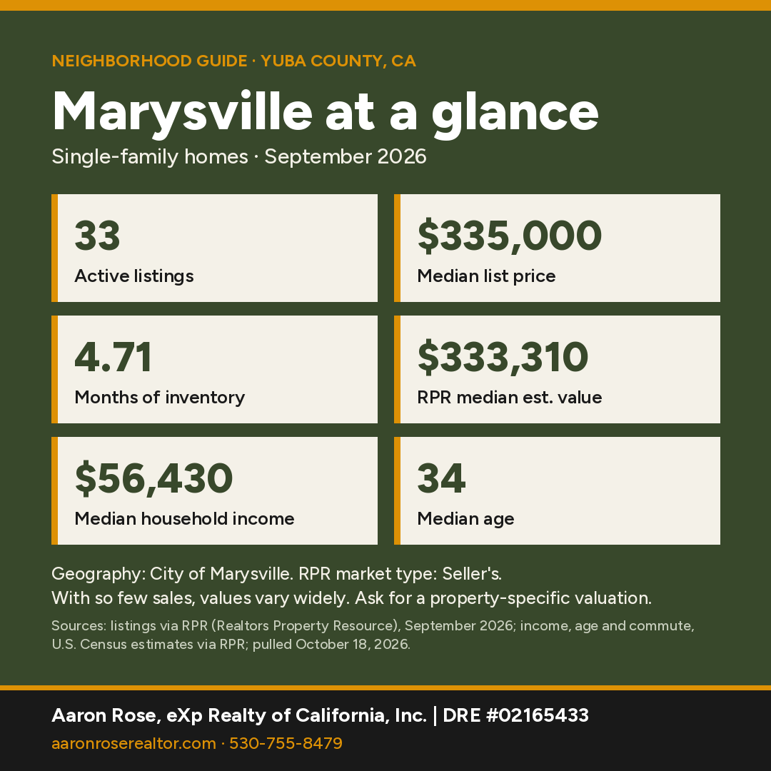
Marysville at a glance
Sources: market figures, City of Marysville, single-family, Sept 2026 (RPR); income, age and commute, U.S. Census estimates for the City of Marysville via RPR, pulled October 18, 2026.
With so few sales, values vary widely, and a property-specific valuation is the best guide to what a particular home is worth.
Where is Marysville, California?
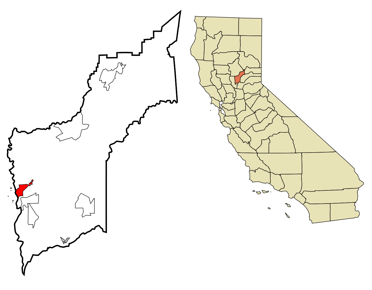
Marysville is the county seat of Yuba County. It sits at the confluence of the Feather and Yuba rivers, about 39 miles (straight-line) north of downtown Sacramento and directly across the Feather River from Yuba City, at roughly 60 feet elevation. The 2020 Census counted 12,844 residents and 5,098 housing units on 3.5 square miles of land, up from 12,072 in 2010. Levees ring the city. The Appeal-Democrat and Sacramento Bee credit them with keeping Marysville compact and giving it the nickname "California's Oldest Little City."
County and ZIP: The city lies entirely in Yuba County and in ZIP 95901. That ZIP area is much larger than the city (35,840 residents in 2020). It includes the neighboring Linda CDP and stretches far to the northeast, with a sliver crossing into Butte County (about 3% of its land). Check the city limits and county for any 95901 address.
What is the history of Marysville?
Per the California State Library, Charles Covillaud had a ranch at a riverboat stop called Yubaville. In early 1850 the new town was named for his wife, Mary Murphy Covillaud, a survivor of the Donner Party. Local historians date the town's founding to January 18, 1850. It was incorporated on February 5, 1851, as the eighth city in the new state per the Appeal-Democrat (a later Appeal-Democrat item says ninth). Marysville was where steamboats coming up the Feather River could go no farther, which made it the supply "Gateway to the Goldfields." After hydraulic-mining debris raised the Yuba riverbed and caused severe floods, the city built the levees that surround it today.

Chinese miners and merchants made Marysville a major Chinese American center. Per the NRHP nomination summary, the permanent Chinese population reached about 1,000 by 1860, and the city was known as Sam Fou. The Bok Kai Temple (California Historical Landmark No. 889) was dedicated on March 21, 1880, replacing an 1850s temple nearby. The Office of Historic Preservation says it has served as a meeting hall, court, school and place of worship, and that its central deity, Bok Eye, the water god, has been celebrated in Marysville on "Bomb Day" since Chinese settled here.

What are Marysville's main neighborhoods?
Historic Commercial District (downtown): This National Register district (#99000692, listed 1999) covers parts of 14 blocks bounded by First, Sixth, C and E Streets, with 59 contributing buildings from 1850 to 1949. Highlights include D Street's storefronts, the 1946 Tower Theater, the Hotel Marysville and the Hart Building. The nomination calls the Hart Building probably the tallest commercial structure between Sacramento and Portland when it was built.

Historic Chinatown (First and C Streets): The streets near the Bok Kai Temple, along the Yuba River levee, hold the Suey Sing Chamber of Labor and Commerce and other contributing buildings.

Ellis Lake area: Ellis Lake sits at the city's center along Highway 20 (B and Ninth Streets area). Per the Living New Deal, landscape architect John McLaren laid it out in 1924 on an old slough of the Yuba River. WPA crews added rip-rap banks, stone lampposts, a fountain, tennis courts, an island bridge and a boat landing in 1939–40.

Just outside the levees: Unincorporated Linda (21,654 residents) and Olivehurst (16,595) to the east and south are larger than the city itself, by 2020 Census count. Beale Air Force Base is about 13 miles (straight-line) to the east.
What amenities and services does Marysville have?
Marysville's amenities include Adventist Health and Rideout hospital, Yuba College's nearby Marysville campus, Ellis Lake, two riverfronts and historic theaters.
- Adventist Health and Rideout hospital, 726 4th Street
- Yuba College's Marysville campus, 2088 N. Beale Road, a Marysville address in Linda
- Ellis Lake's walking paths
- The Feather and Yuba riverfronts
- Downtown's historic theaters
What schools serve Marysville?
Every point we sampled inside the city falls in Marysville Joint Unified School District under Census/NCES EDGE boundaries. NCES lists MJUSD schools within the city limits, including Marysville High (12 E. 18th St.), Covillaud Elementary (628 F St.), Kynoch Elementary (1905 Ahern St.) and Anna McKenney Intermediate, plus charter and county programs. District lines don't follow ZIP codes or community names, so buyers should confirm the district and school assignment for a specific address with the Yuba County Office of Education's School District Locator or the district office.
How local schools rate in RPR (school ratings in Realtors Property Resource for the City of Marysville, pulled October 18, 2026):
- Marysville Charter Academy for the Arts High School (charter) (High): A
- CORE Charter School (charter) (K-12): A
- Covillaud Elementary School (Elementary): B
- Marysville High School (High): B-
- Kynoch Elementary School (Elementary): C+
- Anna McKenney Intermediate Middle School (Middle): C+
- Paragon Collegiate Academy School (charter) (Elementary/Middle (charter)): C+
Ratings are third-party summaries, and district lines don't follow ZIP codes or community names, so confirm the school assignment for a specific address with the district office.
How far is Marysville from Sacramento?
Marysville is about 39 miles (straight-line) north of downtown Sacramento; Highway 70 runs south toward Sacramento, and Sacramento International Airport is about 31 miles away.
State Highways 70 and 20 meet in Marysville. Highway 70 runs south toward Sacramento (about 39 miles straight-line) and Sacramento International Airport (about 31 miles). Highway 20 crosses the Feather River west to Yuba City and runs east into the foothills. Drive times vary by address, so ask Aaron for a route check from a specific property.
Thinking about buying in Marysville?
With RPR's median estimated home value around $333,310 (City of Marysville), a pre-qualification letter shows sellers you're ready and helps you move fast when the right home lists. It's free, with no obligation.
Get Pre-QualifiedWhat are homes like in Marysville?
Inside the levees, expect older single-family homes, Victorian and early-1900s houses near downtown and Ellis Lake, and some multi-unit buildings. Newer subdivisions are mostly outside the city in Linda, Olivehurst and Plumas Lake. Flood-zone status and insurance are standard due-diligence items here.
Home prices right now
RPR recorded only 4 single-family sales in Marysville in September 2026, too few for a meaningful median sold price, so this guide doesn't quote one.
RPR showed 33 active listings (median list price $335,000, or $241 per square foot), 10 new listings and 8 pending sales in September 2026. That works out to 4.71 months of inventory, which RPR classifies as a seller's market. RPR's median estimated home value is $333,310, down 0.9% over 12 months.
With so few sales, values vary widely, and a property-specific valuation is the best guide to what a particular home is worth.
Who lives here: Census estimates for the City of Marysville reported by RPR put the population at about 13,000, the median age at 34 and median household income at $56,430 (U.S. Census via RPR, pulled October 18, 2026).
Geography: City of Marysville, single-family, Sept 2026 (RPR). Source: listings and public records via RPR (Realtors Property Resource); pulled October 18, 2026.
Own in Marysville? See what it's worth.
Get a free, no-obligation value estimate for your home.
See What It's WorthHow does Marysville compare with nearby towns?
| Town | Median sold | Sold in month | Median days | Months supply | Sold-to-list |
|---|---|---|---|---|---|
| Marysville only 4 sales |
Too few sales | 4 | Too few sales | 4.71 | Too few sales |
| Yuba City | $450,000 | 26 | 26 | 3.36 | 99.1% |
| Browns Valley ZIP 95918 |
Too few sales | Fewer than 3 | Too few sales | 6 | Too few sales |
| Loma Rica Yuba County figures |
$470,000 | 49 | 35 | 3.84 | 100% |
| Oroville | $299,000 | 17 | 27 | 5.52 | 99.2% |
Single-family homes, September 2026. Source: listings via RPR (Realtors Property Resource), pulled October 18, 2026. Where a town had too few sales of its own, its row uses the ZIP code or county shown under its name. "Too few sales" means RPR reported no figure, or the town had under 5 sales, too few for a meaningful median. Towns with few sales can swing month to month.
See all Northern California neighborhood guides.
Things every buyer should know in Marysville
Flood zones
Excluding mapped water (Census hydrography), our check of FEMA's National Flood Hazard Layer found about 35% of the land inside the 2020 Census boundary in a Special Flood Hazard Area (A/AE zones, including AE floodway). Marysville sits at the junction of the Yuba and Feather rivers and is ringed by levees. Construction on the U.S. Army Corps of Engineers' 7.6-mile Marysville Ring Levee is complete, and FEMA's map labels much of the area inside it Zone X, "area with reduced flood risk due to levee." The levee is not yet FEMA-certified: per the Appeal-Democrat, the city planned to submit certification documents in 2026 with approval expected in 2027 and a federal deadline of 2030, and without certification the area inside the levee could be remapped into a flood hazard zone, raising flood insurance costs. Look up any address on the FEMA Flood Map Service Center. Federally regulated lenders require flood insurance for homes in a mapped Special Flood Hazard Area (A or AE zones).
Fire hazard zones and insurance
Our check of the state's 2025 Local Responsibility Area map against the 2020 Census city boundary found mostly non-wildland (unzoned) area with no hazard zones, and no High or Very High zones inside city limits. Wildfire exposure affects homeowners insurance availability and price. Get quotes during your inspection period, not after; if the standard market declines, the California FAIR Plan is the state's insurer of last resort and is usually paired with a separate difference-in-conditions policy. Confirm any parcel on the CAL FIRE viewer and in the Natural Hazard Disclosure.
Water
The Cal Water Marysville District serves the city from groundwater wells. Confirm the provider with Cal Water's district lookup.
Older homes
Marysville has many pre-1950 homes near downtown. Budget for inspections of foundations, sewer laterals, electrical and lead-based paint (federal disclosure applies to homes built before 1978).
Internet
Check providers and speeds for a specific address on the CPUC California Interactive Broadband Map.
Nearby communities
All Northern California guides →
Marysville FAQ
What is the median home price in Marysville?
Only 4 single-family homes sold in Marysville in September 2026 (listings via RPR), too few for a meaningful median sold price, so this guide doesn't quote one. RPR showed 33 active listings with a median list price of $335,000 and a median estimated home value of $333,310 (City of Marysville, single-family, September 2026). With so few sales, values vary widely, and a property-specific valuation is the best guide to what a particular home is worth.
Where is Marysville, California?
Marysville is the Yuba County seat, at the confluence of the Feather and Yuba rivers, about 39 miles (straight-line) north of Sacramento and across the Feather River from Yuba City.
Is Marysville in Yuba County or Sutter County?
Marysville is entirely in Yuba County. Yuba City, across the river, is in Sutter County.
Why is Marysville called California's Oldest Little City?
It was one of California's first incorporated cities (February 5, 1851), but levees around it have kept it small, with 12,844 residents in 2020.
What school district serves Marysville?
Census/NCES boundaries place the entire city in Marysville Joint Unified School District, which runs Marysville High School. Confirm assignments by address.
What is the Bok Kai Temple?
A Chinese temple dedicated in 1880 at First and D Streets. It is California Historical Landmark No. 889, honoring Bok Eye, the water god, and has served as a meeting hall, court, school and place of worship.
What ZIP code is Marysville?
The city is in ZIP 95901, which also covers Linda and a large area to the northeast. Check city limits for any address.
What kind of homes are in Marysville?
Inside the levees, expect older single-family homes, Victorian and early-1900s houses near downtown and Ellis Lake, and some multi-unit buildings. Newer subdivisions are mostly outside the city in Linda, Olivehurst and Plumas Lake.
Is Marysville in a fire hazard severity zone?
Our check of the state's 2025 Local Responsibility Area map against the 2020 Census city boundary found mostly non-wildland (unzoned) area with no hazard zones, and no High or Very High zones inside city limits. Confirm any address on the CAL FIRE viewer.
Let's find your place in Marysville.
Whether you're buying, selling or comparing Marysville with nearby towns, Aaron can pull current numbers for a specific area and walk you through the trade-offs.
Contact AaronCall 530-755-8479See Recent SalesSources & Photo Credits (37)
- Realtors Property Resource (RPR): Marysville and comparison-town market activity, Census-based demographics and school ratings
- TIGERweb 2020 Incorporated Places layer (POP100, HU100, AREALAND)
- TIGERweb Census 2010 Incorporated Places layer
- https://www2.census.gov/geo/docs/maps-data/data/rel2020/zcta520/tab20_zcta520_county20_natl.txt
- Census geocoder 9×9 grid sampling inside the 2020 city boundary
- https://epqs.nationalmap.gov/ (USGS elevation)
- NCES EDGE 2023-24 public school locations within the city boundary (polygon query)
- https://www.yubacoe.org/schools-directory/directory/school-districts
- https://www.appeal-democrat.com/gold-rush-was-citys-heyday-marysville-once-seemed-destined-to-be-a-metropolis/article_4d5a3795-eac0-5a62-89a7-4dddc51bfa59.html
- https://www.appeal-democrat.com/news/today-in-history-1851-great-expectations-as-marysville-conducting-first-election-since-incorporation/article_283e2c32-f581-11ef-92e5-7378826a30eb.html
- https://www.sacbee.com/news/local/article314577747.html
- https://celebratecalifornia.library.ca.gov/the-harrowing-journey-of-mary-of-marysville/ (California State Library)
- https://marysville.mjusd.com/About-Us/History/index.html (Marysville High School history page)
- https://ohp.parks.ca.gov/listedresources/Detail/889 (CHL 889, Bok Kai Temple)
- https://noehill.com/yuba/nat1999000692.aspx (NRHP #99000692 summary adapted from the nomination); https://npgallery.nps.gov/NRHP/GetAsset/NRHP/99000692_text
- https://livingnewdeal.org/sites/ellis-lake-park-project-marysville-ca/
- https://www.adventisthealth.org/rideout/locations/adventist-health-and-rideout/
- https://yc.yccd.edu/about/locations/
- California Civil Code §1102.19 (defensible-space documentation at sale; text verified Oct 18, 2026)
- CPUC California Interactive Broadband Map
- Cal Water: Find My District
- Cal Water: Marysville District
- California Department of Insurance: residential insurance consumer resources
- California Department of Insurance: California FAIR Plan
- CAL FIRE/OSFM Local Responsibility Area FHSZ data (FHSZLRA25_v1, 2025), intersected with the 2020 Census city boundary on Oct 18, 2026
- FEMA Flood Map Service Center
- Appeal-Democrat: Marysville levee certification status (FEMA submittal 2026, approval expected 2027, deadline 2030)
- U.S. Army Corps of Engineers: Marysville Ring Levee
- FEMA National Flood Hazard Layer (flood hazard zones), intersected Oct 18, 2026
- CAL FIRE Fire Hazard Severity Zone Viewer
Photos (hosted by Wikimedia Commons; public domain or Creative Commons as credited):
- Noellegi · CC BY-SA 4.0: Bok Kai.jpg
- Arkyan · CC BY-SA 3.0: Yuba County California Incorporated and Unincorporated areas Marysville Highlighted.svg
- California Historical Society Digital Collection · No known restrictions: View of D Street, Marysville, Cal. (9826844675).jpg
- Frank Schulenburg · CC BY-SA 4.0: Bok Kai Temple, Marysville, March 2022-3400.jpg
- Frank Schulenburg · CC BY-SA 4.0: Suey Sing Chamber of Labor and Commerce-3377.jpg
- Publichall · CC BY-SA 3.0: Hart Bldg - Marysville, CA.JPG
- Mchavez · Public domain: MarysvilleEllisLake.jpg
Facts were checked against the sources above in October 2026. Market figures are single-family, one month, and change monthly. Hazard-zone percentages are our approximate GIS overlays; confirm by address. Distances are straight-line.
Aaron Rose, REALTOR® | DRE #02165433 | eXp Realty of California, Inc. | Broker DRE #01878277 | 530-755-8479 · aaron.rose@exprealty.com. Market data: listings via RPR (Realtors Property Resource), single-family homes. Information is deemed reliable but not guaranteed and may change; buyers should independently verify all information, including county, ZIP, school district, hazard zones and property details for a specific address. Equal Housing Opportunity. Last updated October 18, 2026.
For Sale
- 1/62 62
 Active
$ 449,900
4 Beds3 Baths2,469 SqFt5523 Ravine, Marysville, CA 95901
Single Family Home
Listed by eXp Realty of California Inc.

- 1/36 36
 Active
$ 319,000
2 Beds1 Bath1,043 SqFt821 I ST, Marysville, CA 95901
Single Family Home
Listed by eXp Realty of California Inc.
- 1/51 51
 Price Dropped by $5K
$ 244,500
3 Beds2 Baths1,204 SqFt103 E 17th #20, Marysville, CA 95901
Condo
Listed by eXp Realty of California Inc.
- 1/31 31
 Price Dropped by $10K
$ 249,900
2 Beds1 Bath975 SqFt918 12th ST, Marysville, CA 95901
Single Family Home
Listed by eXp Realty of California Inc.
- 1/33 33
 Price Dropped by $4K
$ 194,900
2 Beds2 Baths896 SqFt131 E 17th ST #35, Marysville, CA 95901
Condo
Listed by eXp Realty of California Inc.
- 1/7 7
 Price Dropped by $5K
$ 230,000
3 Beds1 Bath1,040 SqFt23 2nd ST, Marysville, CA 95901
Single Family Home
Listed by eXp Realty of California Inc.
- 3D
 Active
$ 435,000
6 Beds4 Baths2,432 SqFt721 6th ST, Marysville, CA 95901
Single Family Home
Listed by eXp Realty of California Inc.
- 1/32 32
 Active
$ 175,000
2 Beds2 Baths1,152 SqFt2225 Cheim BLVD #12, Marysville, CA 95901
Condo
Listed by eXp Realty of California Inc.
- 1/3 3
 Active
$ 249,000
2 Beds2 Baths1,000 SqFt12287 Loma Rica RD, Marysville, CA 95901
Mobile Home
Listed by eXp Realty of California Inc.
- 1/26 26
 Active
$ 575,000
9,679 Sqft Lot10 E 12th ST, Marysville, CA 95901
Commercial
Listed by eXp Realty of California Inc.
- 1/33 33
 Active
$ 425,000
2,295 SqFt307 B street, Marysville, CA 95901
Multi-Family
Listed by eXp Realty of California Inc.
- 1/35 35
 Active
$ 225,000
40 Acres11923 Loma Rica RD, Marysville, CA 95901
Vacant Land
Listed by eXp Realty of California Inc.
 Active
$ 99,000
2,552 Sqft Lot306 C ST, Marysville, CA 95901
Commercial
Listed by eXp Realty of California Inc.
- 1/6 6
 Active
$ 125,000
5,645 Sqft Lot123 3rd St, Marysville, CA 95901
Commercial
Listed by eXp Realty of California Inc.
- 1/32 32
 Open Sat 11AM-1PM
$ 439,000
3 Beds2 Baths1,505 SqFt5516 Sunhaven ST, Marysville, CA 95901
Single Family Home
Listed by eXp Realty of Northern California, Inc.
- 1/30 30
 New
$ 44,900
2 Beds1 Bath756 SqFt1523 N Beale RD #36, Marysville, CA 95901
Manufactured Home
Listed by Capital's Finest, Inc.
- 1/31 31
 New
$ 450,000
4 Beds3 Baths2,129 SqFt5563 Meadow Brook WAY, Marysville, CA 95901
Single Family Home
Listed by Mallow Real Estate Services
- 1/25 25
 New
$ 129,000
2 Beds2 Baths783 SqFt2019 Hammonton Smartsville RD #48, Marysville, CA 95901
Manufactured Home
Listed by Showcase Real Estate
- 1/33 33
 New
$ 460,000
3 Beds2 Baths2,200 SqFt2253 Buchanan, Marysville, CA 95901
Single Family Home
Listed by Providence Properties
- 1/21 21
 New
$ 319,000
2 Beds2 Baths1,603 SqFt1324 E Covillaud ST, Marysville, CA 95901
Single Family Home
Listed by Real Estate Source Inc
- 3D
 New
$ 295,000
2 Beds1 Bath1,084 SqFt128 E 12th ST, Marysville, CA 95901
Single Family Home
Listed by Dream Real Estate Group
- 1/34 34
 New
$ 279,500
2 Beds1 Bath896 SqFt1224 G ST, Marysville, CA 95901
Single Family Home
Listed by Made 4 More Realty
- 1/32 32
 Active
$ 419,000
4 Beds2 Baths1,624 SqFt2431 Chele AVE, Marysville, CA 95901
Single Family Home
Listed by Valley Fair Realty Corporation
- 1/77 77
 Active
$ 285,000
2 Beds1 Bath973 SqFt903 4th, Marysville, CA 95901
Single Family Home
Listed by Wesely & Associates
- 1/24 24
 Active
$ 249,000
2 Beds1 Bath960 SqFt1228 I ST, Marysville, CA 95901
Single Family Home
Listed by Black Bird Realty
- 1/72 72
 Active
$ 314,000
2 Beds1 Bath1,164 SqFt528 I ST, Marysville, CA 95901
Single Family Home
Listed by Perry Realty
- 1/12 12
 Price Dropped by $20K
$ 195,000
2 Beds1 Bath810 SqFt1611 N C ST, Marysville, CA 95901
Single Family Home
Listed by Century 21 Select Real Estate
- 1/29 29
 Price Dropped by $5K
$ 295,000
3 Beds2 Baths1,700 SqFt708 12th ST, Marysville, CA 95901
Single Family Home
Listed by Amy Hendrix, RE Broker
- 1/14 14
 Price Dropped by $3K
$ 36,950
2 Beds1 Bath500 SqFt1523 N Beale #49, Marysville, CA 95901
Manufactured Home
Listed by Harmony Communities, Inc.
- 1/23 23
 Price Dropped by $20K
$ 195,000
4 Beds2 Baths1,200 SqFt1973 Hammonton Smartsville Rd, Marysville, CA 95901
Single Family Home
Listed by eXp Realty of Northern California, Inc.
RECENTLY SOLD
Image
Address
Sold Date
Property Type
Configuration
Price

1147 Johnson AVE, Marysville, CA 95901
Single Family Home
3 Beds2 Baths1,416 SqFt
$ 363,000 $ 369,500 1.8%
Listed by eXp Realty of California Inc.

8890 Daguerra Point DR, Marysville, CA 95901
Single Family Home
3 Beds3 Baths1,500 SqFt
$ 585,000 $ 595,000 1.7%
Listed by eXp Realty of California Inc.

7300 Ames RD, Marysville, CA 95901
Single Family Home
3 Beds3 Baths2,296 SqFt
$ 580,000 $ 595,000 2.5%
Listed by eXp Realty of California Inc.

1122 E 19th ST, Marysville, CA 95901
Single Family Home
3 Beds1 Bath1,014 SqFt
$ 285,000 $ 299,000 4.7%
Listed by eXp Realty of California Inc.

7315 Doc Adams Rd, Marysville, CA 95901
Single Family Home
3 Beds2 Baths1,344 SqFt
$ 369,000 $ 369,000
Listed by RE/MAX Gold Yuba City

770 Ramirez RD, Marysville, CA 95901
Single Family Home
6 Beds4 Baths3,487 SqFt
$ 600,000 $ 650,000 7.7%
Listed by Century 21 Select Real Estate
housing detail
Coming Soon
Listing Detail
Commute Score
Coming Soon
demographics
Population
Density
Households
Gender
Coming Soon
Education
Coming Soon
Coming Soon
Coming Soon
Nearby Locations
5523 Ravine, Marysville, CA 95901
4 Beds 3 Baths 2,469 SqFt
Single Family Home
Listed by eXp Realty of California Inc.
821 I ST, Marysville, CA 95901
2 Beds 1 Bath 1,043 SqFt
Single Family Home
Listed by eXp Realty of California Inc.103 E 17th #20, Marysville, CA 95901
3 Beds 2 Baths 1,204 SqFt
Condo
Listed by eXp Realty of California Inc.918 12th ST, Marysville, CA 95901
2 Beds 1 Bath 975 SqFt
Single Family Home
Listed by eXp Realty of California Inc.131 E 17th ST #35, Marysville, CA 95901
2 Beds 2 Baths 896 SqFt
Condo
Listed by eXp Realty of California Inc.23 2nd ST, Marysville, CA 95901
3 Beds 1 Bath 1,040 SqFt
Single Family Home
Listed by eXp Realty of California Inc.1891 River Bank DR, Marysville, CA 95901
4 Beds 3 Baths 2,469 SqFt
Single Family Home
Listed by eXp Realty of California Inc.528 Harris ST, Marysville, CA 95901
4 Beds 2 Baths 1,686 SqFt
Single Family Home
Listed by eXp Realty of California Inc.721 6th ST, Marysville, CA 95901
6 Beds 4 Baths 2,432 SqFt
Single Family Home
Listed by eXp Realty of California Inc.5551 Turnberry, Marysville, CA 95901
4 Beds 2 Baths 2,188 SqFt
Single Family Home
Listed by eXp Realty of California Inc.2157 Mickelson DR, Marysville, CA 95901
3 Beds 2 Baths 1,104 SqFt
Single Family Home
Listed by eXp Realty of California Inc.2225 Cheim BLVD #12, Marysville, CA 95901
2 Beds 2 Baths 1,152 SqFt
Condo
Listed by eXp Realty of California Inc.12287 Loma Rica RD, Marysville, CA 95901
2 Beds 2 Baths 1,000 SqFt
Mobile Home
Listed by eXp Realty of California Inc.10 E 12th ST, Marysville, CA 95901
9,679 Sqft Lot
Commercial
Listed by eXp Realty of California Inc.307 B street, Marysville, CA 95901
2,295 SqFt
Multi-Family
Listed by eXp Realty of California Inc.11923 Loma Rica RD, Marysville, CA 95901
40 Acres
Vacant Land
Listed by eXp Realty of California Inc.306 C ST, Marysville, CA 95901
2,552 Sqft Lot
Commercial
Listed by eXp Realty of California Inc.123 3rd St, Marysville, CA 95901
5,645 Sqft Lot
Commercial
Listed by eXp Realty of California Inc.5516 Sunhaven ST, Marysville, CA 95901
3 Beds 2 Baths 1,505 SqFt
Single Family Home
Listed by eXp Realty of Northern California, Inc.1523 N Beale RD #36, Marysville, CA 95901
2 Beds 1 Bath 756 SqFt
Manufactured Home
Listed by Capital's Finest, Inc.
MARKET TRENDS

GET MORE INFORMATION