
CA
Browns Valley
Foothill Area Guide · Yuba County
Browns Valley, California
Browns Valley is a rural, unincorporated Yuba County community in the Sierra foothills where Marysville Road meets Highway 20, about 12 miles (straight-line) northeast of Marysville.
Explore the full Browns Valley neighborhood guideHide the full Browns Valley guide

Foothill Area Guide · Yuba County
Browns Valley, California
A Gold Rush stage stop turned quiet foothill community at Highway 20 and Marysville Road
The Yuba River near Browns Valley, c. 1900. Image: Unknown photographer · Public domain
The short answer
What is it like to live in Browns Valley?
Browns Valley is a rural, unincorporated Yuba County community in the Sierra foothills where Marysville Road meets Highway 20, about 12 miles (straight-line) northeast of Marysville. Expect oak-studded ranch land, homes on acreage and Collins Lake close by for camping, boating and fishing.
- County: Yuba County (all of ZIP 95918)
- Population: 2,259 residents in ZIP 95918 (2020 Census; not a CDP)
- ZIP: 95918
- Elevation: About 270 ft
- Schools: Marysville Joint Unified for nearly all of ZIP 95918 (Browns Valley Elementary)
- Nearest city: About 12 miles (straight-line) northeast of downtown Marysville
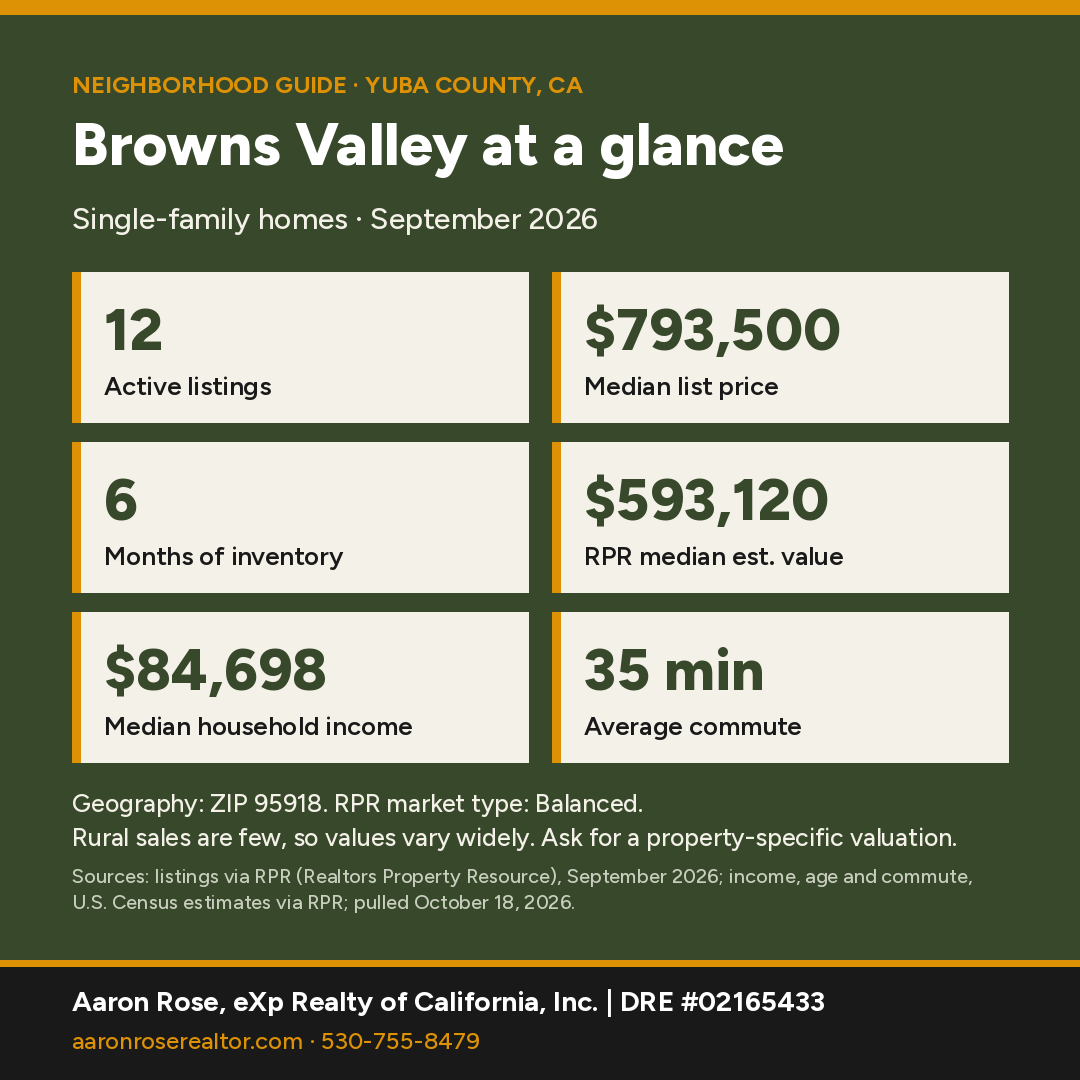
Browns Valley at a glance
Sources: market figures, ZIP 95918, single-family, Sept 2026 (RPR); income, age and commute, U.S. Census estimates for ZIP 95918 via RPR, pulled October 18, 2026.
Rural sales are few, so values vary widely, and a property-specific valuation is the best guide to what a particular home is worth.
Where is Browns Valley, California?
Browns Valley is an unincorporated community in Yuba County, set in the Sierra Nevada foothills where Marysville Road meets State Highway 20, about 12 miles (straight-line) northeast of downtown Marysville at roughly 270 feet elevation.
Browns Valley isn't a Census-designated place, so the best Census snapshot is its ZIP code. ZIP 95918 lies entirely within Yuba County and counted 2,259 residents and 984 housing units in the 2020 Census, across about 56 square miles of land. Part of the Loma Rica CDP also falls inside 95918.
What is the history of Browns Valley?
Browns Valley dates to the Gold Rush: per local historical markers, a settler named Brown struck a rich quartz vein here in 1850.
Historical markers in front of the Browns Valley Post Office (5538 Marysville Road, a mile north of Highway 20) tell the story. The Maidu had lived in the valley for generations before the Gold Rush. In 1850 a settler named Brown struck a rich quartz vein, reportedly took out more than $12,000 in gold, and left only his name behind.
According to the E Clampus Vitus marker "Browns Valley: 1850–1860," the town became a stage stop and mining camp with 5 hotels and 24 saloons. Freight wagons and mule trains left from here for the mines and lumber camps in the high country, and one of the first quartz stamp mills was built here in 1851. The same marker says that by the 1860s the town had more than 3,000 residents and the nickname "Little Washoe."

The Yuba County Historic Resources Commission notes that Chinese and Irish immigrants who came for mining work built many of the rock walls still seen around Browns Valley. It also notes that the Sweet Vengeance Mine was founded by six African American men. The Donnebrouge Mine head frame still stands just up Marysville Road. It's on private property and visible only from the marker, and the mine was last worked in the 1950s. A 2016 Trails West marker near Highway 20 marks the Henness Pass Road, quoting an emigrant's September 1855 diary entry about the road from Oregon House.

What is there to do in and around Browns Valley?
Expect rural foothill living with oak-studded ranch land and acreage parcels. The local recreation hub is Collins Lake Recreation Area (7530 Collins Lake Rd, Browns Valley). Its operator describes a 1,600-acre lake and recreation area with 12 miles of shoreline, plus RV and tent camping, a marina, boat rentals and a swimming beach. The lake is the reservoir behind the Browns Valley Irrigation District's Virginia Ranch Dam, a 152-foot dam completed in 1963. Per BVID, the lake holds 57,000 acre-feet and covers 975 acres when full.
What schools serve Browns Valley?
Census school-district boundaries (TIGER/NCES EDGE) put nearly all of ZIP 95918, and every point we sampled around the community center, in Marysville Joint Unified School District. One sample point at the far southern edge of the ZIP fell in Wheatland Elementary and Wheatland Union High. NCES lists Browns Valley Elementary (MJUSD) at 9555 Browns Valley School Rd. District lines don't follow ZIP codes or community names, so buyers should confirm the district and school assignment for a specific address with the Yuba County Office of Education's School District Locator or the district office.
How local schools rate in RPR (school ratings in Realtors Property Resource for ZIP 95918, pulled October 18, 2026):
- Browns Valley Elementary School (Elementary): B+
Ratings are third-party summaries, and district lines don't follow ZIP codes or community names, so confirm the school assignment for a specific address with the district office.
How far is Browns Valley from Marysville?
Browns Valley is about 12 miles (straight-line) northeast of downtown Marysville.
Browns Valley sits right on State Highway 20, which runs west to Marysville and Yuba City and east toward Smartsville and Grass Valley. Marysville Road heads north from Highway 20 toward Oregon House and Dobbins. Drive times vary by address, so ask Aaron for a route check from a specific property.
Census estimates for ZIP 95918 reported by RPR put the average travel time to work at about 35 minutes.
Thinking about buying in Browns Valley?
With RPR's median estimated home value around $593,120 (ZIP 95918), a pre-qualification letter shows sellers you're ready and helps you move fast when the right home lists. It's free, with no obligation.
Get Pre-QualifiedWhat are homes like in Browns Valley?
Housing here is mostly rural: homes on acreage, ranches and land across the foothills, with 984 housing units in ZIP 95918 at the 2020 Census. Aaron's own office is in Browns Valley at 5363 Marysville Rd.
Home prices right now
RPR had too few single-family sales in ZIP 95918 (the Browns Valley area) in September 2026 to report a median sold price, so this guide doesn't quote one.
RPR showed 12 active listings (median list price $793,500, or $296 per square foot) and 3 new listings in September 2026. That works out to 6 months of inventory, which RPR classifies as a balanced market. RPR's median estimated home value is $593,120, down 5% over 12 months.
Rural sales are few, so values vary widely, and a property-specific valuation is the best guide to what a particular home is worth.
Who lives here: Census estimates for ZIP 95918 reported by RPR put the population at about 2,000, the median age at 44, median household income at $84,698 and owner-occupied homes at 92% (U.S. Census via RPR, pulled October 18, 2026).
Geography: ZIP 95918, single-family, Sept 2026 (RPR). Source: listings and public records via RPR (Realtors Property Resource); pulled October 18, 2026.
How does Browns Valley compare with nearby towns?
| Town | Median sold | Sold in month | Median days | Months supply | Sold-to-list |
|---|---|---|---|---|---|
| Browns Valley ZIP 95918 |
Too few sales | Fewer than 3 | Too few sales | 6 | Too few sales |
| Loma Rica Yuba County figures |
$470,000 | 49 | 35 | 3.84 | 100% |
| Smartsville ZIP 95977 |
Too few sales | Fewer than 3 | Too few sales | 9 | Too few sales |
| Marysville only 4 sales |
Too few sales | 4 | Too few sales | 4.71 | Too few sales |
| Oregon House ZIP 95962 |
Too few sales | Fewer than 3 | Too few sales | 8 | Too few sales |
Single-family homes, September 2026. Source: listings via RPR (Realtors Property Resource), pulled October 18, 2026. Where a town had too few sales of its own, its row uses the ZIP code or county shown under its name. "Too few sales" means RPR reported no figure, or the town had under 5 sales, too few for a meaningful median. Towns with few sales can swing month to month.
See all Northern California neighborhood guides.
Things every buyer should know in Browns Valley
Fire hazard zones and insurance
Browns Valley isn't a Census-mapped place, so we checked the town-center point: it sits in the State Responsibility Area (CAL FIRE is responsible for wildland fire protection), mapped High Fire Hazard Severity Zone, with High and Very High zones within about 2 miles. Because High and Very High zones are mapped here, check the defensible-space rule for sales (Civil Code §1102.19): for a home in one of those zones, the seller must give the buyer documentation of compliance where a local ordinance requires it, or, where a government or qualified nonprofit agency offers inspections, documentation from an inspection in the six months before the sale. If the seller hasn't obtained it, buyer and seller sign a written agreement for the buyer to get it (within one year after closing where no local ordinance applies). Ask the local fire agency which applies. Wildfire exposure affects homeowners insurance availability and price. Get quotes during your inspection period, not after; if the standard market declines, the California FAIR Plan is the state's insurer of last resort and is usually paired with a separate difference-in-conditions policy. Ask about roof age, ember-resistant vents, clearance and the distance to the nearest fire station and hydrant or water source, since carriers price on those. Confirm any parcel on the CAL FIRE viewer and in the Natural Hazard Disclosure.
Wells and septic
Outside the cities, most homes use a private well and an onsite septic system (OWTS). Yuba County Environmental Health permits septic construction and repair under Ordinance Code 7.07: standard systems need 48 inches of effective soil, and sites that don't qualify need an alternative design. Alternative/advanced systems carry an annual operating permit and a recorded right-of-entry agreement. Ask the seller for the septic permit and pumping records, and budget for a septic inspection and a well yield and water-quality test.
Water
Much of the area is within Browns Valley Irrigation District (about 55,000 acres), which supplies irrigation water. Drinking water usually comes from a private well. Ask whether the parcel has BVID irrigation service.
Road maintenance
Many rural roads here are private. Yuba County uses County Service Areas (CSAs), funded by property-owner assessments, to maintain roads in some subdivisions; Yuba LAFCo counted 44 CSAs, most serving privately maintained roads. Before you buy, confirm whether the access road is county-maintained, in a CSA, or private, and get any recorded road-maintenance agreement.
Animals and agricultural zoning
Yuba County's Development Code (§11.32.050) sets animal limits by zone and parcel size. One animal unit equals one horse or cow, two pigs, four sheep or goats, or 20 poultry or rabbits; enclosures must sit 50 feet from neighboring homes and 100 feet from wells and year-round waterways. Within the Valley Growth Boundary, residential zones allow 1 unit per acre with caps. Check the parcel's zoning before you bring horses or livestock.
Flood zones
Our check of FEMA's National Flood Hazard Layer across a 1.5 km circle around the town center found about 4% in a mapped Special Flood Hazard Area (zones A), which can include creek, river and lake surfaces. Look up any address on the FEMA Flood Map Service Center. Federally regulated lenders require flood insurance for homes in a mapped Special Flood Hazard Area (A or AE zones).
Nearby communities
All Northern California guides →
Moving here from the Bay Area?
Redfin's San Francisco County median sale price was $1,661,282 (Sept 2026); RPR's median estimated value in ZIP 95918 is $593,120 (RPR, Sept 2026).
- Internet: check the exact address on the CPUC broadband map.
- Water: Much of the area is within Browns Valley Irrigation District, which supplies irrigation water; drinking water usually comes from a private well.
- Insurance: wildfire exposure affects price and availability; quote it during escrow. The FAIR Plan is the last resort, and defensible space is required up to 100 feet.
Selling first? See what your home is worth. Ready to look? Search homes for sale.
"Aaron was exceptionally good to work with and a very nice guy." Tammy A., Google review. 5.0 from 31 reviews (Oct 18, 2026). Read all reviews
Browns Valley FAQ
What is the median home price in Browns Valley?
RPR doesn't report a median sold price for Browns Valley for September 2026, because too few single-family homes sold in ZIP 95918 (the Browns Valley area). RPR showed 12 active listings with a median list price of $793,500 and a median estimated home value of $593,120 (ZIP 95918, single-family, September 2026). Rural sales are few, so values vary widely, and a property-specific valuation is the best guide to what a particular home is worth.
Where is Browns Valley, California?
Browns Valley is an unincorporated community in Yuba County at State Highway 20 and Marysville Road, about 12 miles (straight-line) northeast of Marysville.
Is Browns Valley in Yuba County?
Yes. Browns Valley and its entire 95918 ZIP code lie in Yuba County, per the 2020 Census ZIP-to-county relationship file.
What school district serves Browns Valley?
Census/NCES boundaries put nearly all of ZIP 95918 in Marysville Joint Unified School District, which operates Browns Valley Elementary. A small southern edge of the ZIP falls in the Wheatland districts. Confirm by address.
How many people live in Browns Valley?
Browns Valley isn't a Census-designated place. ZIP 95918 had 2,259 residents and 984 housing units in the 2020 Census.
What is there to do near Browns Valley?
Collins Lake Recreation Area in Browns Valley offers camping, boating, fishing and a swimming beach. The town's Gold Rush history is told on historical markers in front of the post office on Marysville Road.
How did Browns Valley get its name?
Per the local E Clampus Vitus marker, a settler named Brown struck a rich gold-bearing quartz vein here in 1850, took out more than $12,000 and left, leaving only his name.
Is Browns Valley good for acreage or ranch property?
Housing here is mostly rural: homes on acreage, ranches and land across the foothills, with 984 housing units in ZIP 95918 at the 2020 Census.
Is Browns Valley in a fire hazard severity zone?
Browns Valley isn't a Census-mapped place, so we checked the town-center point: it sits in the State Responsibility Area (CAL FIRE is responsible for wildland fire protection), mapped High Fire Hazard Severity Zone, with High and Very High zones within about 2 miles. Because High and Very High zones are mapped here, check the defensible-space rule for sales (Civil Code §1102.19): for a home in one of those zones, the seller must give the buyer documentation of compliance where a local ordinance requires it, or, where a government or qualified nonprofit agency offers inspections, documentation from an inspection in the six months before the sale. If the seller hasn't obtained it, buyer and seller sign a written agreement for the buyer to get it (within one year after closing where no local ordinance applies). Ask the local fire agency which applies. Confirm any address on the CAL FIRE viewer.
What should I know before relocating to Browns Valley from the Bay Area?
For comparison, Redfin's median sale price in San Francisco County was $1,661,282 in September 2026, and RPR's median estimated home value for single-family homes in ZIP 95918 was $593,120 (September 2026; RPR had too few sales for a median sold price). Before you move to Browns Valley, confirm internet service for the exact address on the CPUC broadband map, get homeowners insurance quotes during escrow (the California FAIR Plan is the state's insurer of last resort), and confirm the water and sewer or septic setup for the property.
Let's find your place in Browns Valley.
Whether you're buying, selling or comparing Browns Valley with nearby towns, Aaron can pull current numbers for a specific area and walk you through the trade-offs.
Contact AaronCall 530-755-8479See Recent SalesSources & Photo Credits (35)
- Realtors Property Resource (RPR): Browns Valley and comparison-town market activity, Census-based demographics and school ratings
- https://tigerweb.geo.census.gov/arcgis/rest/services/TIGERweb (2020 Census CDP/ZCTA layers: POP100, HU100, AREALAND)
- https://www2.census.gov/geo/docs/maps-data/data/rel2020/zcta520/tab20_zcta520_county20_natl.txt
- https://geocoding.geo.census.gov/geocoder/ (county, ZCTA, CDP, school-district layers; grid sampling)
- https://epqs.nationalmap.gov/ (USGS elevation)
- https://nces.ed.gov/opengis/rest/services/K12_School_Locations/EDGE_GEOCODE_PUBLICSCH_2324/MapServer (NCES EDGE 2023-24 school locations)
- https://www.yubacoe.org/schools-directory/directory/school-districts
- https://tigerweb.geo.census.gov/arcgis/rest/services/TIGERweb/Transportation/MapServer (TIGER road names)
- https://www.hmdb.org/m.asp?m=40153
- https://www.hmdb.org/m.asp?m=40159
- https://www.hmdb.org/m.asp?m=54217
- https://www.hmdb.org/m.asp?m=284161
- https://yubacountyhistory.com/wp-content/uploads/2025/02/Yuba-County-Historic-Resources-Commission-Report-2-11-25.pdf (Yuba County Historic Resources Commission, Feb 2025)
- https://collinslake.com/
- https://dbw.parks.ca.gov/BoatingFacilities/f/622
- https://www.bvid.org/dam
- California Civil Code §1102.19 (defensible-space documentation at sale; text verified Oct 18, 2026)
- CPUC California Interactive Broadband Map
- Browns Valley Irrigation District FAQ
- Yuba Water Agency: partnering districts
- California Department of Insurance: residential insurance consumer resources
- California Department of Insurance: California FAIR Plan
- CAL FIRE/OSFM State Responsibility Area FHSZ data (FHSZSRA_23_3, effective April 1, 2024), intersected with the 2020 Census place boundary or town point on Oct 18, 2026
- FEMA Flood Map Service Center
- FEMA National Flood Hazard Layer (flood hazard zones), intersected Oct 18, 2026
- CAL FIRE State Responsibility Area boundaries (SRA22_2), point check Oct 18, 2026
- CAL FIRE Fire Hazard Severity Zone Viewer
- Yuba County Environmental Health: Alternative/Advanced OWTS (annual operating permit)
- Yuba County Development Code Ch. 11.32 (§11.32.050 Animal Raising and Keeping)
- Yuba County Public Works: County Service Areas (road maintenance)
- Yuba LAFCo: County Service Areas service review (2013)
- Yuba County Environmental Health: Sewage Disposal Program (Ordinance Code 7.07, OWTS Manual)
Photos (hosted by Wikimedia Commons; public domain or Creative Commons as credited):
- Unknown photographer · Public domain: The Yuba River, near Browns Valley, California (c. 1900).jpg
- U.S. Geological Survey · Public domain: CA Browns Valley 295951 1911 31680 geo (PDF).pdf
- U.S. Geological Survey, via UT Austin PCL Map Collection · Public domain: Smartsville 1886 1-125,000 - PCL Map Collection - txu-pclmaps-topo-ca-smartsville-1886.jpg
Facts were checked against the sources above in October 2026. Market figures are single-family, one month, and change monthly. Hazard-zone percentages are our approximate GIS overlays; confirm by address. Distances are straight-line.
Aaron Rose, REALTOR® | DRE #02165433 | eXp Realty of California, Inc. | Broker DRE #01878277 | 530-755-8479 · aaron.rose@exprealty.com. Market data: listings via RPR (Realtors Property Resource), single-family homes. Information is deemed reliable but not guaranteed and may change; buyers should independently verify all information, including county, ZIP, school district, hazard zones and property details for a specific address. Equal Housing Opportunity. Last updated October 19, 2026.
eXp Realty of California, Inc. | DRE #02165433
For Sale
- 1/57 57
 Active
$ 640,000
2 Beds3 Baths3,614 SqFt6769 Therese TRL, Browns Valley, CA 95918
Single Family Home
Listed by eXp Realty of California Inc.

- 1/87 87
 Active
$ 675,000
3 Beds3 Baths4,082 SqFt9844 Township RD, Browns Valley, CA 95918
Single Family Home
Listed by eXp Realty of California Inc.
- 1/21 21
 Active
$ 120,000
4.84 Acres13812 Willow Glen RD, Browns Valley, CA 95918
Vacant Land
Listed by eXp Realty of California Inc.
- 1/13 13
 Active
$ 180,000
5.6 Acres Lot0 Marysville RD, Browns Valley, CA 95918
Commercial
Listed by eXp Realty of California Inc.
- 1/98 98
 New
$ 4,600,000
3 Beds2 Baths2,600 SqFt6841 Marysville Rd, Browns Valley, CA 95918
Multi-Family
Listed by eXp Realty of Northern California, Inc.
- 1/48 48
 Active
$ 799,000
4 Beds3 Baths2,756 SqFt6217 Sandstone LN, Browns Valley, CA 95918
Single Family Home
Listed by Nikos Krohn Realty
- 1/62 62
 Active
$ 430,000
2 Beds2 Baths1,568 SqFt9719 Gary Dr, Browns Valley, CA 95918
Single Family Home
Listed by Realty ONE Group Complete
- 1/59 59
 Active
$ 449,000
2 Beds2 Baths1,152 SqFt11365 Shadow LN, Browns Valley, CA 95918
Single Family Home
Listed by Wesely & Associates
- 1/81 81
 Active
$ 875,000
2 Beds3 Baths1,700 SqFt10415 Township RD, Browns Valley, CA 95918
Single Family Home
Listed by Vista Sotheby's International Realty
- 1/45 45
 Active
$ 675,000
4 Beds4 Baths1,894 SqFt6026 Clair DR, Browns Valley, CA 95918
Single Family Home
Listed by eXp Realty of Northern California, Inc.
- 1/65 65
 Active
$ 689,000
4 Beds4 Baths2,950 SqFt7428 Yore Way, Browns Valley, CA 95918
Single Family Home
Listed by Aztec Real Estate
- 1/58 58
 Active
$ 969,000
4 Beds5 Baths4,005 SqFt6717 Heleen Bart CT, Browns Valley, CA 95918
Single Family Home
Listed by Realty Direct Group
- 1/61 61
 Price Dropped by $35K
$ 889,000
4 Beds3 Baths3,250 SqFt9830 Deer Hollow TRL, Browns Valley, CA 95918
Single Family Home
Listed by BERKSHIRE HATHAWAY Home Services NorCal Real Estate
- 1/71 71
 Active
$ 625,000
3 Beds2 Baths1,410 SqFt10823 Peoria RD, Browns Valley, CA 95918
Single Family Home
Listed by Providence Properties
- 1/49 49
 Active
$ 355,000
2 Beds1 Bath1,488 SqFt11592 Peoria, Browns Valley, CA 95918
Single Family Home
Listed by Core Real Estate Brokerage
- 1/9 9
 Price Dropped by $10K
$ 329,999
3 Beds2 Baths1,248 SqFt6322 Bayberry LN, Browns Valley, CA 95918
Manufactured Home
Listed by eXp Realty of Northern California, Inc.
- 3D
 Active
$ 748,000
3 Beds3 Baths2,523 SqFt14158 Neptune LN, Browns Valley, CA 95918
Single Family Home
Listed by Aztec Real Estate
- 1/59 59
 Price Dropped by $15K
$ 525,000
3 Beds2 Baths1,639 SqFt10420 Sabiniana RD, Browns Valley, CA 95918
Single Family Home
Listed by HomeSmart ICARE Realty
- 1/39 39
 Price Dropped by $61K
$ 888,000
3 Beds2 Baths2,782 SqFt5072 Banca CT, Browns Valley, CA 95918
Single Family Home
Listed by Showcase Real Estate
- 1/61 61
 Active
$ 1,190,000
4 Beds2 Baths2,400 SqFt7133 Lilly WAY, Browns Valley, CA 95918
Single Family Home
Listed by Hilbers Legacy Properties
RECENTLY SOLD
Image
Address
Sold Date
Property Type
Configuration
Price

5900 Bald Mountain RD, Browns Valley, CA 95918
Single Family Home
3 Beds2 Baths1,727 SqFt
$ 520,000 $ 525,000 1.0%
Listed by eXp Realty of California Inc.

7095 Marysville RD, Browns Valley, CA 95918
Manufactured Home
2 Beds2 Baths1,632 SqFt
$ 400,000 $ 400,000
Listed by eXp Realty of California Inc.

11306 Peoria RD, Browns Valley, CA 95918
Vacant Land
6.16 Acres
$ 40,000 $ 49,000 18.4%
Listed by Berkshire Hathaway HomeServices Heritage, REALTORS

0 SPRING VALLEY, Browns Valley, CA 95918
Vacant Land
11.57 Acres
$ 145,000 $ 150,000 3.3%
Listed by Five Star Realty

13978 Cascade WAY, Browns Valley, CA 95918
Vacant Land
20.03 Acres
$ 170,000 $ 170,000
Listed by eXp Realty of California Inc.

0 Oak Grove CT, Browns Valley, CA 95918
Vacant Land
7.45 Acres
$ 185,000 $ 195,000 5.1%
Listed by eXp Realty of California Inc.
housing detail

Coming Soon
Listing Detail
Commute Score
Coming Soon
demographics
Population
Density
Households
Gender
Coming Soon
Education
Coming Soon
Coming Soon
Coming Soon
Nearby Locations
6769 Therese TRL, Browns Valley, CA 95918
2 Beds 3 Baths 3,614 SqFt
Single Family Home
Listed by eXp Realty of California Inc.
9844 Township RD, Browns Valley, CA 95918
3 Beds 3 Baths 4,082 SqFt
Single Family Home
Listed by eXp Realty of California Inc.13812 Willow Glen RD, Browns Valley, CA 95918
4.84 Acres
Vacant Land
Listed by eXp Realty of California Inc.0 Marysville RD, Browns Valley, CA 95918
5.6 Acres Lot
Commercial
Listed by eXp Realty of California Inc.6841 Marysville Rd, Browns Valley, CA 95918
3 Beds 2 Baths 2,600 SqFt
Multi-Family
Listed by eXp Realty of Northern California, Inc.6217 Sandstone LN, Browns Valley, CA 95918
4 Beds 3 Baths 2,756 SqFt
Single Family Home
Listed by Nikos Krohn Realty9719 Gary Dr, Browns Valley, CA 95918
2 Beds 2 Baths 1,568 SqFt
Single Family Home
Listed by Realty ONE Group Complete11365 Shadow LN, Browns Valley, CA 95918
2 Beds 2 Baths 1,152 SqFt
Single Family Home
Listed by Wesely & Associates10415 Township RD, Browns Valley, CA 95918
2 Beds 3 Baths 1,700 SqFt
Single Family Home
Listed by Vista Sotheby's International Realty6026 Clair DR, Browns Valley, CA 95918
4 Beds 4 Baths 1,894 SqFt
Single Family Home
Listed by eXp Realty of Northern California, Inc.7428 Yore Way, Browns Valley, CA 95918
4 Beds 4 Baths 2,950 SqFt
Single Family Home
Listed by Aztec Real Estate6717 Heleen Bart CT, Browns Valley, CA 95918
4 Beds 5 Baths 4,005 SqFt
Single Family Home
Listed by Realty Direct Group9830 Deer Hollow TRL, Browns Valley, CA 95918
4 Beds 3 Baths 3,250 SqFt
Single Family Home
Listed by BERKSHIRE HATHAWAY Home Services NorCal Real Estate10823 Peoria RD, Browns Valley, CA 95918
3 Beds 2 Baths 1,410 SqFt
Single Family Home
Listed by Providence Properties11592 Peoria, Browns Valley, CA 95918
2 Beds 1 Bath 1,488 SqFt
Single Family Home
Listed by Core Real Estate Brokerage6322 Bayberry LN, Browns Valley, CA 95918
3 Beds 2 Baths 1,248 SqFt
Manufactured Home
Listed by eXp Realty of Northern California, Inc.14158 Neptune LN, Browns Valley, CA 95918
3 Beds 3 Baths 2,523 SqFt
Single Family Home
Listed by Aztec Real Estate10420 Sabiniana RD, Browns Valley, CA 95918
3 Beds 2 Baths 1,639 SqFt
Single Family Home
Listed by HomeSmart ICARE Realty5133 Oak Grove CT, Browns Valley, CA 95918
4 Beds 4 Baths 3,172 SqFt
Single Family Home
Listed by Wesely & Associates5072 Banca CT, Browns Valley, CA 95918
3 Beds 2 Baths 2,782 SqFt
Single Family Home
Listed by Showcase Real Estate
MARKET TRENDS


GET MORE INFORMATION